Sunday, September 25, 2022 – It started raining here at the Hot Springs KOA yesterday afternoon, not long after I finished and posted Blog #6. The rain didn’t let up for me to sit outside so I did some other things inside the camper.
After all these weeks of travel around Arkansas, this is the first campground with cable hookup. By choice, I don’t use the camper’s antenna so I was glad to finally be able to use the cable here and turn on my new TV for the first time. Nearly all the networks, unfortunately, were fuzzy, so I left the TV off. I made a mental note to myself to talk to David about the camper’s [2005] antenna and see if today’s technology has something better to offer.
Since I made the decision yesterday to stay here for a third day (today), I decided this morning to treat myself to a pancake breakfast at the KOA’s “Grandpa’s Griddle.” The KOA guys working the griddles did a pretty good job with the spatulas and all.
This week -- the last week in September -- is my final week in Arkansas. It’s almost time for me to start driving west towards home. Back inside the camper after breakfast, I got all my maps and other materials together and started making decisions as to where to go from here and where to stop for the night. Since I’m already in the general southwest part of Arkansas, I decided to focus on this area and managed to secure online reservations at different campgrounds for this week.
Remembering that I treated myself to pancakes this morning I decided to treat myself further with a dip in the pool this evening. The water was cold but refreshing! I saw Greystoke once again, laying on the ground near the KOA office. Taking another picture of this handsome feline, I told him to take good care.

Monday, September 26, 2022 – Leaving the KOA this morning I drove to Hot Springs, a city in the Ouachita Mountains and encompassed within the Hot Springs National Park. Looking for a place to park in this congested hilly city, I finally found a spot on an unmetered curbside street. The Visitor’s Center was nearby and since I didn’t really like where I’d parked, I went inside to inquire about parking for my truck camper. The two ladies there told me they had several angled slots on their parking lot for buses and RVs. Fantastic! I moved my truck camper to one of those slots then went back inside, got information, an area map, and started walking.
Hot Springs, Arkansas is world famous for its hot thermal mineral springs. Formed over millions of years by this region’s unique geological features, humans – beginning with the original inhabitants, of course -- benefited from the relaxing and therapeutic healing aspects of these waters. The arrival of white settlers, and their discovery of the hot spring waters, led to the establishment of bathhouses. And that’s the street I was walking on – Central Avenue, “Bathhouse Row.”
The bathhouses along that block are both fascinating and beautiful. There’s eight of them, built between 1892 and 1923, one right next to the other. They are considerably large structures, up to three levels. The architectural style of each building, both the interior and the exterior, is eye-catching. Except for one bathhouse that wasn’t accessible (I think it’s up for sale) I went inside all the other seven. They’ve been renovated and visitors can enjoy the different services they now provide. Two bathhouses offer spa service, including private baths, massages, facials and other treatments, and there’s a coed pool in one of those two. Others are a gift shop, a restaurant, and a museum. The museum – all three levels -- was especially interesting. These bathhouses definitely catered to wealthy and famous people, men and women both…separately. This online link provides more information about the bathhouses -- https://www.nps.gov/hosp/learn/historyculture/bathhouse-row-today.htm
Located directly behind the Maurice Bathhouse is the “Display Spring,” an example for visitors to see hot water flow from fissures out of a hillside into a shallow pool. Touching that pool of water – hot! Touching that trickle of water – hot! There are also trails right behind Bathhouse Row and a half mile long brick walk/jog/bike path called the Grand Promenade. I walked on part of a trail and then on the promenade to the end of the street. By then it was almost 2:00 p.m., I’d been walking around Bathhouse Row for over two hours…and now I’m hungry! The menu at the “Superior Bathhouse,” when I looked at it earlier, looked good so I went back there. My meal was delicious! A tomato bisque with slices of melted cheese, a one-pound baked potato with mushrooms, onions, spinach, chives, and parmesan…and root beer! I could only eat half the potato so got a take-out container for the other half.


 | ||
According to the signage - "The Quapaw is named after an American Indian tribe that once inhabited land in the area."
|


I thanked Karen again and again for her help and then got myself settled for the evening. This campground is situated on a cove of Lake Ouachita, the largest lake in Arkansas, and I again have a lakeview. After doing my usual stats, I sat outside to write in my journal. As the sun started to set, directly behind me, I enjoyed observing the sunlight’s play on the trees on the other side of the lake.
Tuesday, September
27, 2022 – Since the area around my site was
completely dark last night, I left all my cabover window shades raised…and all the
windows closed. Good thing too because it got cold during the night and I had
to reach for my flannel shirt and the extra blanket (I’d put the sleeping bag
away several weeks ago). With the shade raised at the bedside window facing east,
this morning’s sunrise came through that window. Noticing the mist rising from
the lake as the sky became brighter, I got right out of bed, put on my shoes,
and stepped outside to take pictures.
The sunrise through the cabover window next to my bed.
I spent my morning on the laptop, enjoying my view of the lake and the
occasional boat, obeying wake rules, motor slowly by. Shortly after 1:15 p.m. I
headed out to drive on Routes 70bE, 270E, and 227N to another section of Lake
Ouachita – the Lake Ouachita State Park. As I’ve been doing at some of the
other state parks during this trip, I brought my laptop inside the Visitor’s
Center, sat at one of their tables and, using their WIFI, caught up on emails and
downloaded pictures from iPhone to laptop. That done I made my way to my
campsite. As I proceeded to back in, I noticed this fellow observing me and I
thought to myself -- “Why pass up an offer if one is made?” Sure enough, he offered to
guide me and I gratefully accepted. Helping me is helpful and they do feel good
about it afterwards. This is how it should be…with everyone…everywhere...
Mist rising from the surface of the lake.
My site pad here, compared to the narrow, gravelly one I had yesterday, is a luxury -- it’s a very long and very level concrete pad. My camper’s back door faces west and since it’s going to be several hours before the sun sets, I left the back door closed to keep the interior shaded and cool. I have a view of the lake, the marina, and several boats anchored here and there on the lake. The sunset, when it soon took place, was lovely, as I always think it is when a body of water is present.

Wednesday, September 28, 2022 – I went to bed last night with sweatpants, socks, and flannel shirt. I was prepared! The cool of the night, under the covers, sure did feel wonderful after going through a daily streak of hot days on this trip. The humidity, I’ve noticed, has decreased considerably. And the leaves, they continue to fall.
Getting out of bed soon as I woke up, I took a short walk along the shoreline closest to my campsite. It was rocky and most of the stones were flat (shale?). Back at my camper, the lady at the site next to me approached and, now understanding why I didn’t respond to her earlier, started conversing with me, slowly and clearly. Our chat was brief because her husband soon came out and was wanting his breakfast, but I did learn that they live in Louisiana and, being that the Lake Ouachita State Park was their favorite, they always come back to this campsite for a two-week stay in their RV. Sitting outside later in my camp chair, the lake in front of me, the rising sun at my back, I had a bowl of Corn Flakes for breakfast and, yup, I agreed with my neighbor – this is indeed a very nice state park.

Lake Ouachita in the morning. 
A panoramic photo of the trees in front of my site.
 |
| All sorts of flying insects make their way into the camper. This one (a mayfly, I later learned from a state park staffer) attached itself on the carpeted ridge above my dinette table. I thought it was quite pretty, thus the photo. I coaxed it onto a piece of paper and it flew off outside. |
Before leaving the state park, I stopped by the Visitor’s Center to use their internet once more. As I walked towards the same tables that I used yesterday, I saw this little girl looking at something in a display case. I took a peek and saw that it was a snake – a female Speckled Kingsnake, according to the sign on the wall. Fascinated by it myself, since it was moving around and flicking its tongue, I stood next to the girl and she struck up a non-stop conversation with me. I was getting a kick out of her chatter but, not wanting to interrupt her repertoire of opinions, or whatever she was saying, I remained silent, using gestures instead to point at the snake and make “Wow” expressions on my face. After a few minutes of this exchange – which included wonderful eye contact between me and this child – her mother, who had been standing at the counter, came by and signed to me – “thank you.” For all I know, the girl’s mother might have said something to her because she later shyly used a teeny-weeny sign with me herself. I responded to that and then, when her mother came back, learned that her father has a deaf sister and he had been teaching his little girl some signs. She knew “mother” and “father” and, wanting me to know that she was four years old, we did the numbers 1-4 together. She insisted her “B” handshape was the appropriate sign for “four” and, knowing I best not argue the issue with a four-year-old female, I let her have her say. She sure was adorable!
At 11:45 a.m. – this being another beautiful and cloudless blue-sky day -- I finally got going on a 2½ hour drive on a series of winding and hilly two-lane roads: Routes 227S-270W-27S-8S-70E-back on 27S and, finally, 301S to the Crater of Diamonds State Park in Murfreesboro. Some of those roads took me back to areas I’d already visited – Glenwood and Daisy State Park, for example – but this just goes to show how I do a lot of zigzagging when I travel in the truck camper.
Arriving at the state park I first noticed the many cars at the parking lot. Wow, diamonds sure are a big draw, I thought. To quote from their brochure – “Crater of Diamonds State Park exists to responsibly manage and interpret this unique site and to provide a meaningful diamond mining experience for all guests and future generations. Among the tall pines of Southwest Arkansas, visitors from around the world search for diamonds in a 37-acre field. Here, a massive volcanic pipe brought diamonds to the earth’s surface. This famous site is the only diamond-producing area in the world open to the public. Although genuine diamonds are the chief attraction to the Crater, other semi-precious stones can also be found. Amethyst, agate, jasper, calcite, and barite are but a few of the gems and minerals that make this Arkansas State Park a rock hound’s delight.” The brochure further states that an average of more than 400 diamonds are found here each year. Notable finds include “The Uncle Sam” in 1924 (40.23 carats); “The Amarillo Starlight” in 1975 (16.37 carats); and more recently in 2017, “Superman’s Diamond” (7.44 carats).
The front entrance to the Visitor’s Center, as is typically designed at the state parks, has two drive-through lanes for RVs to park on while the driver and/or passenger was inside to register. The big RV that was there when I pulled in sort of hogged both lanes, so I decided to wait behind that RV and move forward when they moved on. As soon as I was able to do that another big RV pulled up behind me and that driver – a male -- made a beeline into the Visitor’s Center, never mind that I was actually there first. Ohhh, I was majorly pissed off! And the young lady at the counter knew it. She shook her head and said “People…” I shook my head and said “Men!” After she got me registered, I gave her my best smile and jokingly asked her what site she put that guy on. Nah, never mind, he’ll get his just due some other way some other time.
The state park is in the midst of a woodsy area and tall trees are my campsite view this time. Sitting outside with my journal I looked up and – “Hey, do those two big leafy bowl-like things up there look like nests?” If they are -- bird or squirrel? I’ll have to Google later. [Addendum: This is what I found online - “A squirrel lives in a nest known as a 'drey', comprising of a ball of interwoven twigs, lined inside with soft materials including moss, leaves, grass and fir. Dreys are usually located in the fork of a branch tight against the tree trunk, around two-thirds of the way up the tree.”]
Thursday, September 29, 2022 – Having noticed people yesterday in the Visitor’s Center with their shovels and sifting equipment, and reading the “how to” instructions for dry and wet sifting, I figured the search for even one diamond, or any other precious stone, is really time consuming. You gotta have, not only the time, but an infinite amount of patience, a good eye, and some knowledge or understanding about what to look for in a stone. Some folks do this for fun, others are seriously committed, and others – like me – are simply curious.
At 9:30 a.m. this morning, I was there at the Diamond Crater and spent about two hours just walking around the trail that encircled the restricted search area. I paid $10.00 in the Visitor’s Center for that privilege and, going down to the ground level, saw the enclosure where you can rent equipment – sifting trays, buckets to shovel dirt into, other tools, and a wagon to haul everything. There’s also a professional standing by to verify someone’s find, weigh, and record it. At that point it’s “finders-keepers.”
As mentioned in the brochure, the search field, which is freshly plowed
from time to time, is 37 acres. Walking on or between those plowed ridges of
earth ain’t easy, lemme tell you! But I did that, all the better to get close
enough to observe these folks, sitting on their haunches, and note their
intense concentration as they sifted, loosened dirt with their fingers, picked
something up, tossed it or put it aside. I tried my hand at this, too, picking
up a handful of dirt and sifting the grains through my fingers. Nothing came of
it but I can say I tried.
A lot of plowed earth to sift through! In the background is the historic mineshaft, "the only surviving evidence of possible shaft mining" at this section. 
Try walking on this without stumbling!
 |
| Belinda, from Georgia, gave me permission to take her picture. She said this was her second day of searching. |
 |
| The area for wet sifting. |


Permission granted, Polli said she lives in Texas. She fingerspelled very well, wet fingers and all!
 |
| Even the dogs did some digging! I bumped into the family later and they loved the photo! |
On my way at 12:00 noon, I took a series of two-lane state and county roads to the Rick Evans Grandview Prairie WMA (Wildlife Management Area), located in Hempstead County. The state roads were decently paved but the narrow county roads – the back roads -- were another story. Rough, bumpy, patched tar here, more over there, and none where tar should be! The road directly to the WMA was all gravel. On these roads I drove slowly, practically crawling where it was smarter to do so.
From online – “Rick Evans Grandview Prairie represents the most significant example of blackland prairie existing for management and restoration in Arkansas. It is comprised of open prairie, woodlands, savanna, and non-native grasslands. The diversity of habitat types accounts for the subsequent variety of animals such as songbirds, deer, butterflies, small mammals and reptiles year-round.” Entering the Main Office/Education Center, it took me a few seconds to finally see this lady at her desk in the rear. Her posture and the look on her face told me she’d been saying “Hello, hello,” or something akin to that, and we both smiled a sort of “Ah, there you are” acknowledgment. She answered my questions and, being that this WMA offers a self-drive auto tour, gave me a map of the roads I can drive on. Gravel, of course. She pointed out two lakes and suggested I be sure and stop there. Oh, I definitely will – I’m a sucker for lakes (and rivers and bays and ponds and the sea) as evidenced throughout my Arkansas journey!
The gravel on the WMA roads were easier to drive on – something to do with the gravel being smaller and spread on packed dirt, I think. So, I didn’t mind that and I also didn’t mind that I was the only person there throughout the two hours of my auto tour. I stopped, when and where I wanted, to read posted signs and/or take pictures. Other than one or two turkey vultures gliding around high up in the sky, I saw no animals. The sound of my truck’s engine, I’m well aware, announces my approach even before I get there.
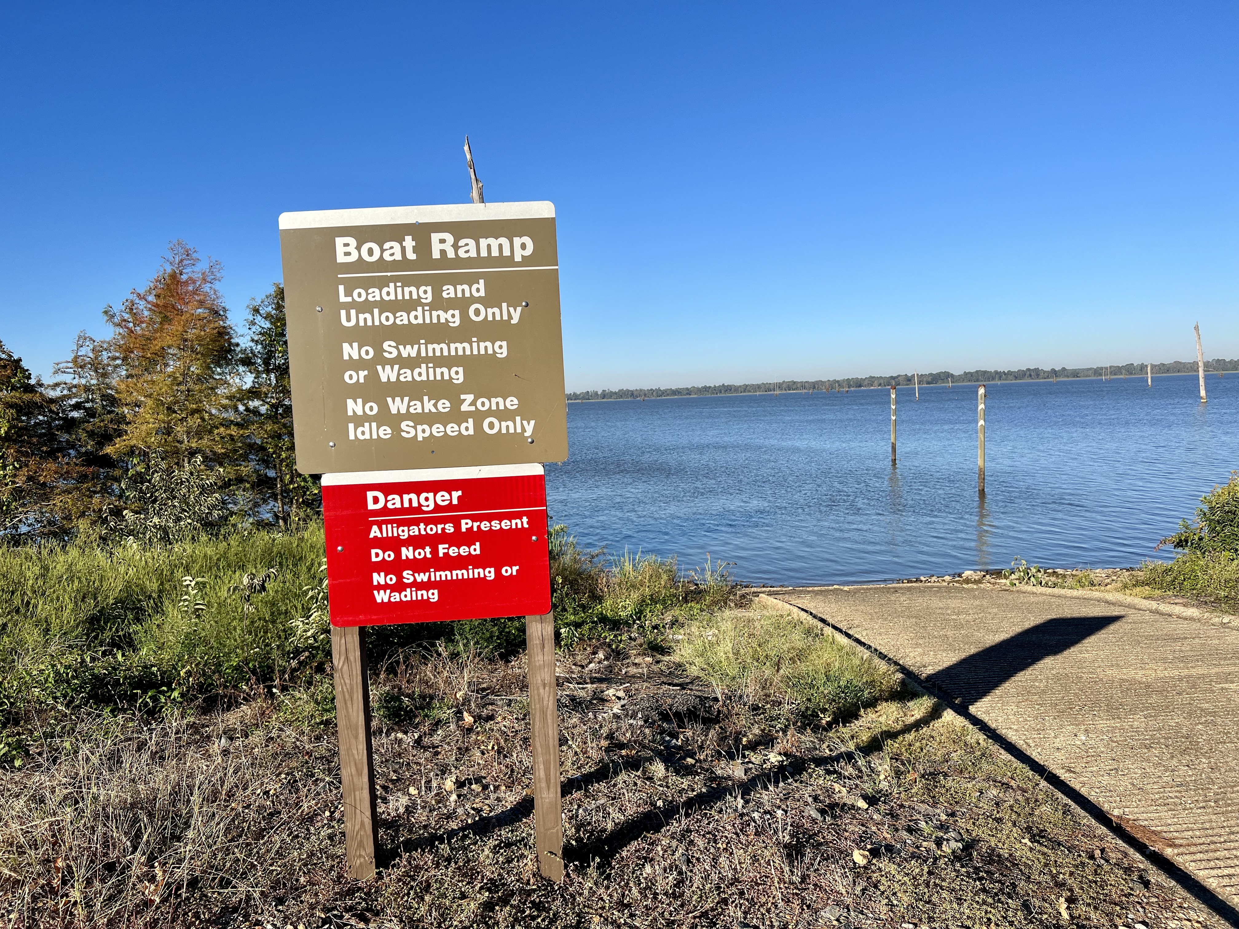
The South Fork Lake was my first stop. As I drove slowly to the parking area, I saw a group of 5-6 white egrets at the water’s edge. I slowed down even more but they all still flew off. Even though there was a boat ramp and a small covered fishing pier, the lake was left entirely in its natural state – trees along the banks, lily pads, reeds, and other plant life. Remembering my binoculars, I went in the camper to retrieve it and, standing at the pier, I scanned the trees, the lily pads, the logs in the water, and everything else. You never know what you might spot – a frog, a turtle, a bird on a branch, maybe a snake. I’m so glad I went to get my binocs because I did spot something – an alligator, on a sandy spot and basking in the sun. It was some yards away and I think it was aware of my presence because it turned its head in my direction. I didn’t find a diamond today, but seeing that alligator, in its natural environment, was all the wealth I needed for my soul. The second lake, Lake Terre Noire, was equally as beautiful. It had a boat ramp, too, but no other man-made structure. Nor an alligator…that I saw anyway.

Embarking on my self-drive "truck tour." 
Wild grassland.
 | ||
Stopping where and when I want to!
|


 | ||
Sunset through the dinette window.
|


 |
| The lone RV on the loop -- mine. |
 |
My last sunset in Arkansas...  'twas icing on the cake! |
Saturday, October 1, 2022 – It was another cold night last night. Getting up at 7:00 a.m., I decided to step outside, open the propane tanks, and turn the heat on in the camper. Might as well test it and get me and camper both warmed up at the same time.
On my way shortly before 9:30 a.m., I headed northwest on several state roads towards the Oklahoma state line. Those scenic two-lane roads [Routes 355N-371N-71N-270N-59N] traversed through the Ouachita National Forest, through small and bigger towns, and through farmland – cattle, horses, goats, and sheep! Seeing the “Oklahoma” sign, I left Arkansas behind with contented thoughts and feelings of an outstanding and memorable one-month journey around the state. THANK YOU, Arkansas!
Around 1:45 p.m., I arrived at the Sallisaw/Fort Smith W KOA, in Sallisaw, Oklahoma. Again, with its internet and amenities, this KOA is a good place for me to stay for a couple of nights to update, edit, and prepare Blog #7 for posting. The lady in the office, after registering me, said their pool is still open…and they have a hot tub, too!
Lovely post! Brings back a memory of a stop at the Hot Springs National park and Clyde and I indulged in a hot spring bath and a massage...it was a wonderful treat! We are enjoying your trip vicariously and your grear photos!
ReplyDeleteLovely photos! Love you, take care.
ReplyDeleteYou seem to meet a lot of people who know a little bit of sign language. I think that's amazing! As always, the lakes and the animals are my favorite parts of your journey. And searching for diamonds? I can only imagine how it would feel to find a 40 carat diamond!
ReplyDelete