Friday, October 14, 2022

“Cows and Calves and the Trek Homeward”

Sunday, October 2, 2022 First thing this morning [while still at the Sallisaw/Fort Smith W KOA, in Sallisaw, OK] I paid bills online, after which I started editing, updating, and inserting pictures for Blog #7. By 4:00 p.m. the blog was ready for posting on my blogsite. That done, and since there was now no reason for me to stay at this KOA tomorrow for a third night, I made reservations at another KOA near El Reno, OK. There I’ll have the time I need to rest a bit and review my travel materials.

Monday, October 3, 2022 I dumped the tanks this morning and, by 10:45 a.m., I left the KOA and got on I-40 W for the drive to El Reno. Most interstates, while not offering much in the way of scenery, are the perfect highway to get from Point A to Point B relatively quickly. I-40 is no exception…but, as history tells it – “Since Route 66 forged an efficient direct path from the Midwest to the west coast, Interstate 40 directly paralleled it through most of the Southwest, rendering most stretches of the older highway obsolete.” What remains of Route 66 are interesting places to visit -- that I discovered during a truck camper trip in April 2007.

Breaking the sightline monotony as I drove along were the billboards – “Casino” here, “Casino” there, “Catfish” up ahead. I was mostly intrigued by Oklahoma’s informative signs letting me know I was leaving such and such tribal reservation and entering another tribal reservation. There were a lot of those signs and they reminded me of the “Trail of Tears” and the historical fact that Oklahoma was the dropping off point for that forced relocation of five different tribes. Wondering why Oklahoma, I found this online -- “Oklahoma was born of this institutionalized racism.’ Under the Indian Removal Act of 1830, the Cherokee, Chickasaw, Choctaw, Creek and Seminole nations – known as the Five Tribes – were forced from their ancestral homelands in the southeast and relocated to “Indian Territory,” as Oklahoma was then designated.”

“Alrighty, MAP, look sharp, Oklahoma City is coming up!” A major city OKC is and I braced myself for the inevitable mess of multi lanes, merging traffic, overpasses, exits on the right and exits on the left, and cars and trucks zooming by me out of nowhere. Focusing intently on this “big city” section of the interstate I held on to the hope that all the drivers on the road with me were also adhering to the well-meaning and oft-given “Drive safely!” counsel.

Soon as I arrived at the El Reno KOA and settled in, I immediately got out my maps, focused on stopping points for the next two nights, and secured reservations at those locations. The sun was setting but with dinner at the nearby Cherokee Restaurant on my mind, I went ahead and walked up the KOA road to the restaurant. Catfish was on the menu and that’s what I had, along with a salad and a couple of side dishes. A cream pie desert was to-go!
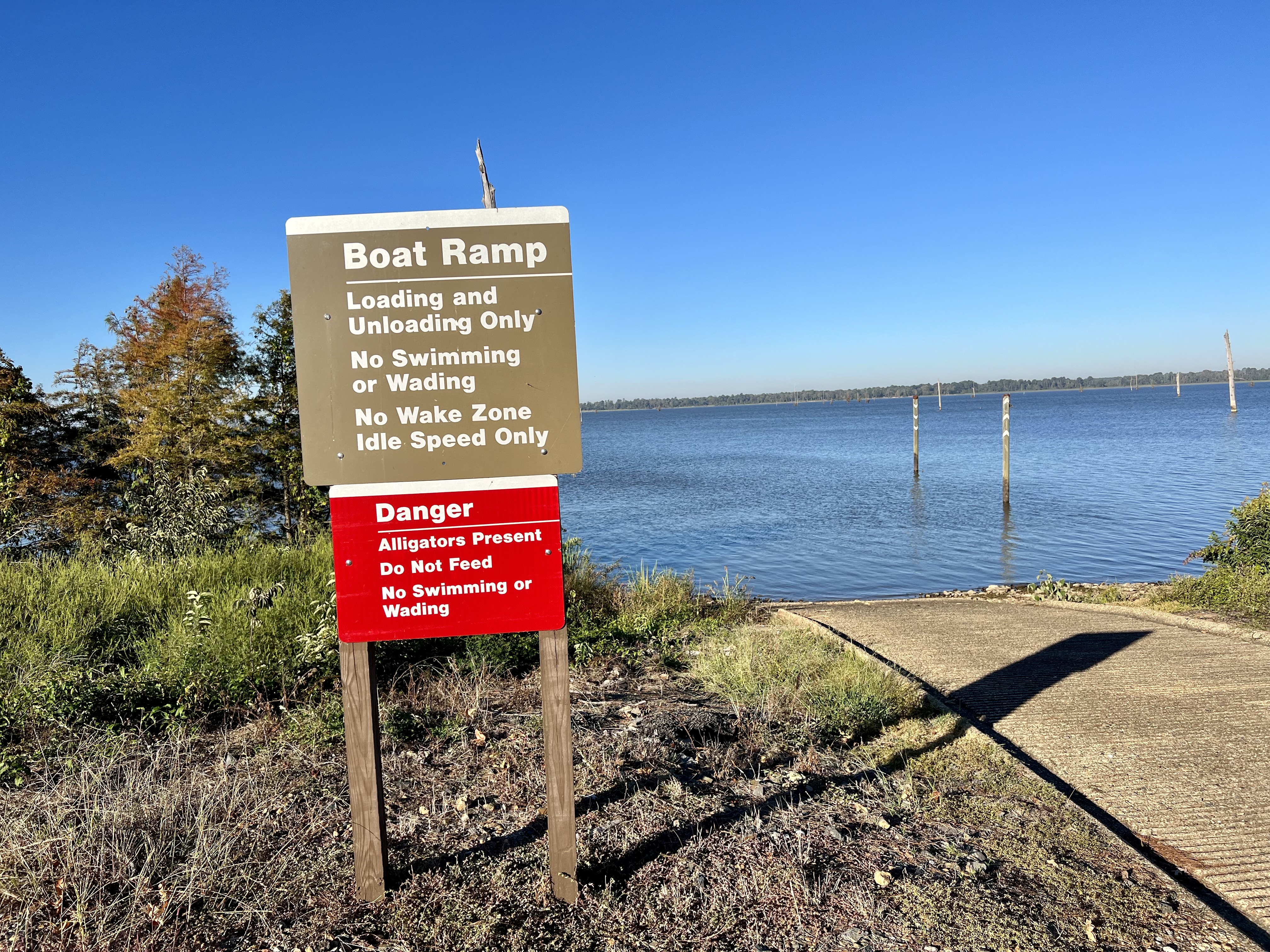
Tuesday, October 4, 2022 I got back on I-40 W and crossed into the Texas Panhandle. About 15 miles from the state line, near Shamrock, I exited the interstate and got on FM 1547, going south. According to an online search, FM is an acronym for “Farm to Market” – A roadway generally in rural areas, so designated by the Texas Transportation Commission.”

My destination on this road – “Lone Mound Ranch,” a Harvest Hosts ranch. As soon as I came upon the entrance, I slowed down and Lana Flint, the owner, waved when she saw me. I drove in, parked, and as we shook hands (Wow, strong grip!), she looked at my camper, gave me a thumbs-up, and led me into her country store to register me. She then gave me a map of the ranch with directions to another nearby gate and pointed out the marked locations of a couple of sites I should go to (she has five areas earmarked for RVs and several cabins on the property available for rent). After becoming acquainted with one another for a brief while, I then made my way to that other gate.

Turning into that driveway, I found the gate closed. Right, this is private property – lemme get out of the truck and check that chain link keeping the gate closed. Right, there’s no lock-and-key padlock, just a spring link clasp hooked to a chain link. Unhooking that clasp, the gate swung wide open. I got back in the truck, drove through the gate, stopped, got out of the truck, closed and secured the gate. This gate business sure did make me feel like a real farmer/rancher!

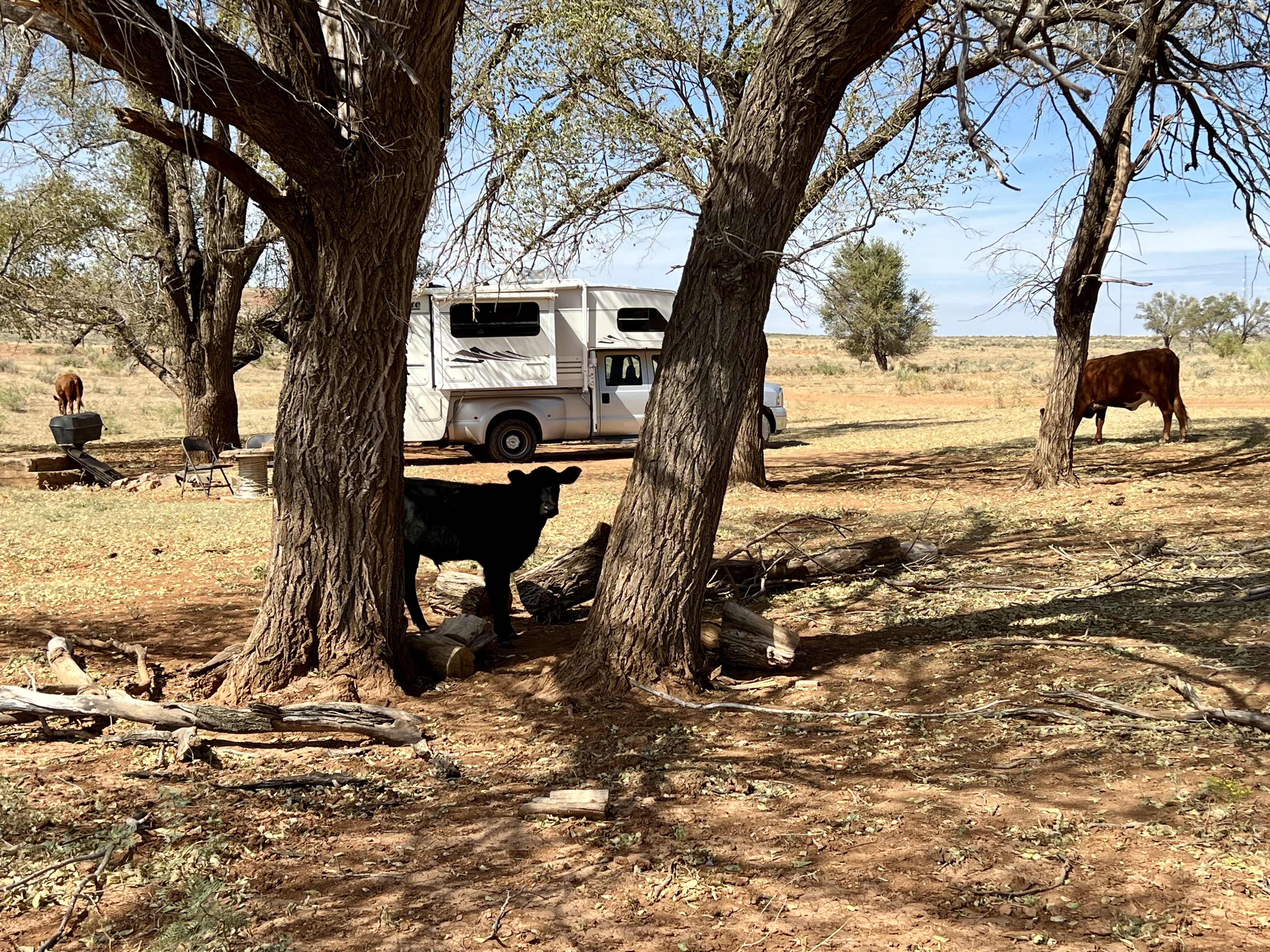
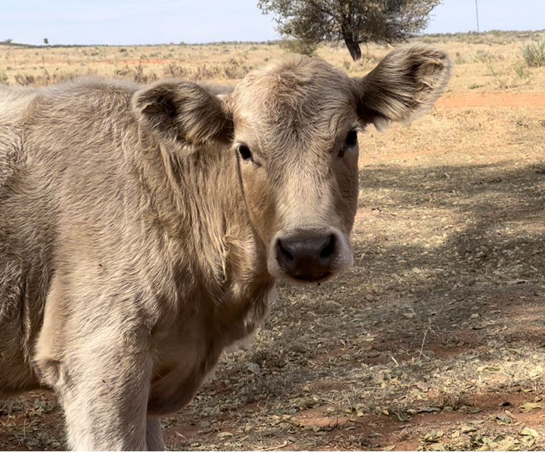
Driving about a quarter mile on the dirt road I spotted the trees that Lana had mentioned. Arriving at that spot [Site #1] there was a gathering of around 15 cows and calves and they paid me no attention as I maneuvered the truck around a bit to find the best and most level ground. The perimeter of Lana’s ranch is fenced and her herd of grass-fed cows roam freely around the property. It’s sheer luck that this group was right there when I arrived and settled in.

Described on Lana’s website as “…a 460-acre, idyllic, high plains, year-round, working cattle ranch,” there are no hookups here. So, since I’m boondocking for the night, I opened the propane tank for the fridge. My new solar panels have been keeping my batteries well charged throughout this trip and I know I have sufficient battery power for the lights inside the camper. I decided not to use the laptop while I’m here so won’t be needing to activate the generator for electricity.

I stepped outside to take pictures of my bovine neighbors. This is a novelty for me, being this close to cows and calves -- and surrounded by their dung, fresh and old both. The cows basically ignored me but the calves were quite intrigued by this human sitting in her camp chair and talking to them. A couple of the calves sauntered over to sniff the front of my truck, probably attracted to the smell of the goo all over the bumper.

Lana said the cows go everywhere on the ranch and I was free to walk around, too. So, I did that. There are a few trees on the property but the acreage is mostly native grass and other foliage that the cows graze on. Oh, yeah, as I walked around, I made a mental note to be sure – and especially before I step inside the camper -- to flick off, with a stick, the prickly sharp burrs sticking to my shoes and socks.

The ranch is named for a ¼-mile long mesa on the property. There’s another smaller mound, not as high, and I chose that one to climb up on. The short footpath up wasn’t difficult but I did need to crouch low to the ground to keep my balance, keeping an eye too on where I put my hands and feet. The view at the top was amazing – the 360-degree expanse of the ranch, the sight of a group of cows up on higher ground, some of the structures on the property (a barn, for one) – and other land and mesas in the distance. And, yup, my camper was right where I left it. What goes up must come down and I was a lot more careful getting back down, again crouching low and watching for loose stones.

Back at the camper, the cows had all moved elsewhere. As the sun started to set, I walked over to the area closer to the barn and took pictures. In reply to my question earlier, Lana verified that it gets very dark at the ranch – there’s no artificial light or light pollution. Oh, but we did have the half-moon tonight, so I didn’t get to see very many stars when I stepped outside just before going to bed.

The dirt road into Lone Mound Ranch.

Cows outside my kitchen window.

A calf...some cows...and a truck camper...on a ranch.

Grazing and paying me no mind!


Clouds add character to an environment -- always.

My truck camper near a piece of ranch equipment.

From the top of the smaller mound.

The smaller mound in the background. 

The setting sun...


Wednesday, October 5, 2022 Waking up to the view of the tell-tale orange band trough my window, I got right out of bed and, stepping around the dung, stood at a couple of spots to take pictures of the sunrise. Since there were no cows around my site this morning, I decided to walk to the barn and see what it looks like up in that area. There were some cows in a corral and one of Lana’s dogs was watching me -- and me him, through my binoculars.

                                                                          Sunrise...


Heading out shortly after 9:00 a.m., opening and closing the gate again, I met up with Lana at her store and made some purchases. In a text exchange with her yesterday, after I informed her that I was all settled in at my spot, she texted –
“It’s not often I see a little lady in such a Boss rig as yours.” (with a smile icon). As I was putting my purchases away in the camper, Lana looked around my camper outside and asked me a question. We got to talking about my camper and she was surprised to learn that my first truck camper trip was in 2006, when I was 56 years old, and that I’m now 72.

Lana pointed to a trailer that was set up behind the store and said that a woman (with respect for her privacy I’ll call her “Ms. K”) had been living in that trailer for the past seven years. Not a minute later, “Ms. K” herself stepped out with her dog and Lana called her over to come meet me. Within a few minutes of talking with her, I thought to myself that she appeared to be very much like those full-time trailer and camper van folks in the book and movie, Nomadland. She said she’s 71 years old, lives off of her social security, and goes where she can find a job for the time being. When I mentioned that sort of lifestyle as portrayed in the movie, “Ms. K” concurred and made a comment about the main character in the movie as not being a “happy person.” Her implication, as I inferred it to be, was that she’s not like that character at all. When I finally left, getting back on FM 1547 and heading for I-40, I felt a sense of wonderment that, in less than 24-hours and way out in this Texas countryside, I met two fascinating and admirable women – strong, independent, self-sustaining, warm, friendly, and content with their lives. Lana’s website - https://lonemoundranch.com.

Driving along on I-40 W I crossed into New Mexico…and gained an hour. Not long after crossing the state line, I exited the interstate and took a couple of state roads to the Ute Lake State Park, in Logan, NM. Since today had been cool and cloudy, with an occasional sprinkling of rain, I stayed inside the camper and did some work on Blog #8 (this one). Figuring I would need heat at some point during the night, I opened the propane tanks…and put my sleeping bag back on the bed.

Thursday, October 6, 2022 It rained during the night, and it continued to rain off and on this morning. I’ve no complaints. Rain is needed and, despite many days of heat and humidity, I had absolutely ideal blue-sky weather during my month-long journey around Arkansas.

I got going around 10:00 a.m., made my way back to I-40, drove on towards Albuquerque, got on I-25 N, and arrived at the Rio Rancho home of Evelyn and David, my sister and brother-in-law.  Having visited them here when I started my trip last August, I’ve come full circle, for a second visit as my trip is now coming to an end.

Friday, October 7, 2022 Ah, how nice it was to wake up under the warm covers of a real bed! How much better it is to be pampered by Ev and David!

Ongoing right now, while I’m here, is the nine-day Albuquerque International Balloon Fiesta, the largest hot air balloon festival in the world. David was up first and, as we stood at the big windows of their house, he pointed to a few hot air balloons already rising from Albuquerque. By the time Ev joined us, there were hundreds of balloons filling the sky. We looked through my binoculars, their binoculars, and David’s telescope. Through the telescope we could make out the many various special balloon shapes such as an emperor penguin, two hugging bears, a spaceship, an ice cream cone, a sloth, to name a few. Around mid-morning, the balloons had moved off to where the winds took them. Quite a show this was to see from our vantage point!

Hot air balloons from the Albuquerque International Balloon Fiesta.

Saturday, October 8, 2022 We woke up to a gray sky and rainy morning but that didn’t deter us from going out to breakfast at the popular Range CafĂ© in Bernalillo. Back home, after doing a bit of online research and getting phone assistance from Ev, I secured a campsite reservation for my very last night in the camper.

When it got dark later in the evening, David set up his telescope out on the patio so we could take a good look at both the full moon and Jupiter, “…the fifth planet from the Sun and the largest in the Solar System.” David said to look for Jupiter’s moons and I could see three of them. As we were taking turns on the telescope, the balloon festival’s fireworks were going off at the same time. Quite a busy night of viewing the universe and the man-made fireworks!

Sunday, October 9, 2022 We said our good-byes around 9:15 a.m....

David, me, and Evelyn...

…and I left, taking the nearby Unser Blvd. directly to I-40. Well on my way westward, it was a cloudy morning (no rain) until I crossed into Arizona, gaining an hour and some sunshine!

By the time I reached the KOA in Flagstaff, AZ, I’d driven a little over five hours. As soon as I got the camper set up on my site, I started bagging clothes, food, and other items – getting a head start on that task for my arrival home.

Monday, October 10, 2022 Woke up to a clear blue-sky morning and, facing another five-hour drive today on I-40 W, I got going at 8:30 a.m. Today’s drive was interesting and, at certain regions along the way, quite spectacular -- going from the cool high altitude and forests of the Flagstaff area to Arizona’s hot low desert environs.

I was finally in California when I crossed the Colorado River near Needles, from where I then got on Rt. 95 and headed south to Blythe. The northern segment of this two-lane Rt. 95 was fun to drive on – a few curves and a LOT of rolling “rollercoaster” dips that made me smile…a LOT! Rt. 95 ended at I-10 and I made my way to the final campground of this trip – The Cove RV Resort, located on the Colorado River. Driving through the entrance, I immediately recognized the place -- I did stay here some years ago for my final night of that trip.

The office was closed but there was a campsite map taped on the glass door for me, telling me that G-20 was my site. I got there only to find a sprinkler right in the middle, happily sprinkling water in all directions. Seeing that there was a sprinkler doing the same thing on G-18, I decided to just go ahead and get settled on G-19. I moved one sprinkler a bit out of the way and turned the other one off as that water was hitting on my slideout. I walked back to the still-closed office and taped a note to the door informing “Linda” that I’m on G-19…and hopefully that’s alright with her. Then I bagged some more stuff and called it a day.

Tuesday, October 11, 2022 – I got right out of bed as soon as I woke up and…

* Stripped off the sheets from the bed;

* Separated laundry piles for later;

* Transferred some bags to the truck for quicker unloading when I get home;

* Turned on the kitchen and bathroom faucets to drain the water into the grey water tank;

* Dumped the black and grey tanks;

* Did some minor interior clean-up.

After all that, I was ready to leave. But first, I gotta go see the Colorado River. My first night in the camper, on August 15th, was at the Colorado River on the Arizona side. Last night was my final night at the California side of the same river. A young bikini-clad woman was at the beach when I approached and she was playing with her three full-grown German Shepherds (or maybe they were Belgian Malinois). I called out to alert her that I was there and to make sure she had her dogs under control. I went a bit further off to the side, put my hands in the water and splashed the cool water on my arms and legs. A swim would be nice, but no, home is calling.

On the way back to the camper, I stopped for a second, thinking about it, and then turned towards the office. It was open and I went inside to introduce myself to Linda, the owner. I mentioned G-19 and she said what I did yesterday was perfectly fine. I told her I had been here before but it was under different management at that time. She said to come back again!

Arriving home at around 1:00 p.m., I immediately unloaded the truck and camper and did one load of laundry. One more thing to do tomorrow…

Wednesday, October 12, 2022 First thing this morning, now that the camper has been completely emptied, I did some interior cleaning. Around 8:45 a.m. I left home, took I-10 W to Ontario, and dropped off the camper for storage at Galaxy Campers. I brought up some minor issues with David, my camper guy, and we agreed to address those before my next truck camper trip. So, until then, this wonderful journey to and around the beautiful state Arkansas is officially over.

STATS:

Total days in Arkansas - 34

Total miles in Arkansas – 1,724

Total days of travel – 58

Total miles of travel – 4,929


ADDENDUM:

After returning to Palm Springs from Ontario on Wednesday, I took the truck for its smog check [for tag renewal]. The test failed because the truck’s catalytic converter was missing! Stolen, obviously, but when and where will remain a mystery. If I had been traveling without the catalytic converter throughout my trip, I find it interesting that no hearing person alerted me to the truck sounding louder or different than it normally does. An unfortunate situation, and truly sad to know the world is full of unscrupulous people. Arkansas reminds me, however, that we are surrounded by GOOD people, too!

Sunday, October 2, 2022

“Bathhouses & Diamonds & Reptiles, Oh My!”

Sunday, September 25, 2022 It started raining here at the Hot Springs KOA yesterday afternoon, not long after I finished and posted Blog #6. The rain didn’t let up for me to sit outside so I did some other things inside the camper.

After all these weeks of travel around Arkansas, this is the first campground with cable hookup. By choice, I don’t use the camper’s antenna so I was glad to finally be able to use the cable here and turn on my new TV for the first time. Nearly all the networks, unfortunately, were fuzzy, so I left the TV off. I made a mental note to myself to talk to David about the camper’s [2005] antenna and see if today’s technology has something better to offer.

Since I made the decision yesterday to stay here for a third day (today), I decided this morning to treat myself to a pancake breakfast at the KOA’s “Grandpa’s Griddle.” The KOA guys working the griddles did a pretty good job with the spatulas and all.

This week -- the last week in September -- is my final week in Arkansas. It’s almost time for me to start driving west towards home. Back inside the camper after breakfast, I got all my maps and other materials together and started making decisions as to where to go from here and where to stop for the night. Since I’m already in the general southwest part of Arkansas, I decided to focus on this area and managed to secure online reservations at different campgrounds for this week.

Remembering that I treated myself to pancakes this morning I decided to treat myself further with a dip in the pool this evening. The water was cold but refreshing! I saw Greystoke once again, laying on the ground near the KOA office. Taking another picture of this handsome feline, I told him to take good care.

Monday, September 26, 2022 Leaving the KOA this morning I drove to Hot Springs, a city in the Ouachita Mountains and encompassed within the Hot Springs National Park. Looking for a place to park in this congested hilly city, I finally found a spot on an unmetered curbside street. The Visitor’s Center was nearby and since I didn’t really like where I’d parked, I went inside to inquire about parking for my truck camper. The two ladies there told me they had several angled slots on their parking lot for buses and RVs. Fantastic! I moved my truck camper to one of those slots then went back inside, got information, an area map, and started walking.

Hot Springs, Arkansas is world famous for its hot thermal mineral springs. Formed over millions of years by this region’s unique geological features, humans – beginning with the original inhabitants, of course -- benefited from the relaxing and therapeutic healing aspects of these waters. The arrival of white settlers, and their discovery of the hot spring waters, led to the establishment of bathhouses. And that’s the street I was walking on – Central Avenue, “Bathhouse Row.”

The bathhouses along that block are both fascinating and beautiful. There’s eight of them, built between 1892 and 1923, one right next to the other. They are considerably large structures, up to three levels. The architectural style of each building, both the interior and the exterior, is eye-catching. Except for one bathhouse that wasn’t accessible (I think it’s up for sale) I went inside all the other seven. They’ve been renovated and visitors can enjoy the different services they now provide. Two bathhouses offer spa service, including private baths, massages, facials and other treatments, and there’s a coed pool in one of those two. Others are a gift shop, a restaurant, and a museum. The museum – all three levels -- was especially interesting. These bathhouses definitely catered to wealthy and famous people, men and women both…separately. This online link provides more information about the bathhouses -- https://www.nps.gov/hosp/learn/historyculture/bathhouse-row-today.htm

Located directly behind the Maurice Bathhouse is the “Display Spring,” an example for visitors to see hot water flow from fissures out of a hillside into a shallow pool. Touching that pool of water – hot! Touching that trickle of water – hot! There are also trails right behind Bathhouse Row and a half mile long brick walk/jog/bike path called the Grand Promenade. I walked on part of a trail and then on the promenade to the end of the street. By then it was almost 2:00 p.m., I’d been walking around Bathhouse Row for over two hours…and now I’m hungry! The menu at the “Superior Bathhouse,” when I looked at it earlier, looked good so I went back there. My meal was delicious! A tomato bisque with slices of melted cheese, a one-pound baked potato with mushrooms, onions, spinach, chives, and parmesan…and root beer! I could only eat half the potato so got a take-out container for the other half.


According to the signage - "The Quapaw is named after an American Indian tribe that once inhabited land in the area."


The Fordyce Bathhouse.


From Hot Springs I got on Routes 70b and 270 and drove west for about 20 miles to the Crystal Springs Campground for tonight’s stay. Using the campground map that I picked up at the entrance, I followed the road layout to my site. Up ahead on the road was a closed gate, and thinking I couldn’t go further, I erroneously drove on the wrong road – a one-way road – looking for my site. This nice lady, having seen me “looking confused” as I drove down that road, walked towards me and stopped me. Karen (I later learned her name) pointed out the location of my site and it was obvious there was no way I could back in the camper onto the site from the direction I was going. I was able to turn around right there and go back up that road to get on the correct one to my site. Karen then helped guide me as I backed in and that help was definitely very much appreciated. My site, not only was it narrow, the back end was a bit close to the edge of a slope. Karen’s line of sight and hand signals helped me make sure I was parked just so. We also had to eyeball this one tree to make sure, because of my slideout, I wasn’t parked too close to it.

I thanked Karen again and again for her help and then got myself settled for the evening. This campground is situated on a cove of Lake Ouachita, the largest lake in Arkansas, and I again have a lakeview. After doing my usual stats, I sat outside to write in my journal. As the sun started to set, directly behind me, I enjoyed observing the sunlight’s play on the trees on the other side of the lake.

Tuesday, September 27, 2022 Since the area around my site was completely dark last night, I left all my cabover window shades raised…and all the windows closed. Good thing too because it got cold during the night and I had to reach for my flannel shirt and the extra blanket (I’d put the sleeping bag away several weeks ago). With the shade raised at the bedside window facing east, this morning’s sunrise came through that window. Noticing the mist rising from the lake as the sky became brighter, I got right out of bed, put on my shoes, and stepped outside to take pictures.

The sunrise through the cabover window next to my bed.

Mist rising from the surface of the lake.

I spent my morning on the laptop, enjoying my view of the lake and the occasional boat, obeying wake rules, motor slowly by. Shortly after 1:15 p.m. I headed out to drive on Routes 70bE, 270E, and 227N to another section of Lake Ouachita – the Lake Ouachita State Park. As I’ve been doing at some of the other state parks during this trip, I brought my laptop inside the Visitor’s Center, sat at one of their tables and, using their WIFI, caught up on emails and downloaded pictures from iPhone to laptop. That done I made my way to my campsite. As I proceeded to back in, I noticed this fellow observing me and I thought to myself -- “Why pass up an offer if one is made?” Sure enough, he offered to guide me and I gratefully accepted. Helping me is helpful and they do feel good about it afterwards. This is how it should be…with everyone…everywhere...

My site pad here, compared to the narrow, gravelly one I had yesterday, is a luxury -- it’s a very long and very level concrete pad. My camper’s back door faces west and since it’s going to be several hours before the sun sets, I left the back door closed to keep the interior shaded and cool. I have a view of the lake, the marina, and several boats anchored here and there on the lake. The sunset, when it soon took place, was lovely, as I always think it is when a body of water is present.

Wednesday, September 28, 2022 I went to bed last night with sweatpants, socks, and flannel shirt. I was prepared! The cool of the night, under the covers, sure did feel wonderful after going through a daily streak of hot days on this trip. The humidity, I’ve noticed, has decreased considerably. And the leaves, they continue to fall.

Getting out of bed soon as I woke up, I took a short walk along the shoreline closest to my campsite. It was rocky and most of the stones were flat (shale?). Back at my camper, the lady at the site next to me approached and, now understanding why I didn’t respond to her earlier, started conversing with me, slowly and clearly. Our chat was brief because her husband soon came out and was wanting his breakfast, but I did learn that they live in Louisiana and, being that the Lake Ouachita State Park was their favorite, they always come back to this campsite for a two-week stay in their RV. Sitting outside later in my camp chair, the lake in front of me, the rising sun at my back, I had a bowl of Corn Flakes for breakfast and, yup, I agreed with my neighbor – this is indeed a very nice state park.

Lake Ouachita in the morning.

A panoramic photo of the trees in front of my site.

All sorts of flying insects make their way into the camper. This one (a mayfly, I later learned from a state park staffer) attached itself on the carpeted ridge above my dinette table. I thought it was quite pretty, thus the photo. I coaxed it onto a piece of paper and it flew off outside. 

Before leaving the state park, I stopped by the Visitor’s Center to use their internet once more. As I walked towards the same tables that I used yesterday, I saw this little girl looking at something in a display case. I took a peek and saw that it was a snake – a female Speckled Kingsnake, according to the sign on the wall. Fascinated by it myself, since it was moving around and flicking its tongue, I stood next to the girl and she struck up a non-stop conversation with me. I was getting a kick out of her chatter but, not wanting to interrupt her repertoire of opinions, or whatever she was saying, I remained silent, using gestures instead to point at the snake and make “Wow” expressions on my face. After a few minutes of this exchange – which included wonderful eye contact between me and this child – her mother, who had been standing at the counter, came by and signed to me – “thank you.” For all I know, the girl’s mother might have said something to her because she later shyly used a teeny-weeny sign with me herself. I responded to that and then, when her mother came back, learned that her father has a deaf sister and he had been teaching his little girl some signs. She knew “mother” and “father” and, wanting me to know that she was four years old, we did the numbers 1-4 together. She insisted her “B” handshape was the appropriate sign for “four” and, knowing I best not argue the issue with a four-year-old female, I let her have her say. She sure was adorable!

At 11:45 a.m. – this being another beautiful and cloudless blue-sky day -- I finally got going on a 2½ hour drive on a series of winding and hilly two-lane roads: Routes 227S-270W-27S-8S-70E-back on 27S and, finally, 301S to the Crater of Diamonds State Park in Murfreesboro. Some of those roads took me back to areas I’d already visited – Glenwood and Daisy State Park, for example – but this just goes to show how I do a lot of zigzagging when I travel in the truck camper.

Arriving at the state park I first noticed the many cars at the parking lot. Wow, diamonds sure are a big draw, I thought. To quote from their brochure – “Crater of Diamonds State Park exists to responsibly manage and interpret this unique site and to provide a meaningful diamond mining experience for all guests and future generations. Among the tall pines of Southwest Arkansas, visitors from around the world search for diamonds in a 37-acre field. Here, a massive volcanic pipe brought diamonds to the earth’s surface. This famous site is the only diamond-producing area in the world open to the public. Although genuine diamonds are the chief attraction to the Crater, other semi-precious stones can also be found. Amethyst, agate, jasper, calcite, and barite are but a few of the gems and minerals that make this Arkansas State Park a rock hound’s delight.” The brochure further states that an average of more than 400 diamonds are found here each year. Notable finds include “The Uncle Sam” in 1924 (40.23 carats); “The Amarillo Starlight” in 1975 (16.37 carats); and more recently in 2017, “Superman’s Diamond” (7.44 carats).

The front entrance to the Visitor’s Center, as is typically designed at the state parks, has two drive-through lanes for RVs to park on while the driver and/or passenger was inside to register. The big RV that was there when I pulled in sort of hogged both lanes, so I decided to wait behind that RV and move forward when they moved on. As soon as I was able to do that another big RV pulled up behind me and that driver – a male -- made a beeline into the Visitor’s Center, never mind that I was actually there first. Ohhh, I was majorly pissed off! And the young lady at the counter knew it. She shook her head and said “People…” I shook my head and said “Men!” After she got me registered, I gave her my best smile and jokingly asked her what site she put that guy on. Nah, never mind, he’ll get his just due some other way some other time.

The state park is in the midst of a woodsy area and tall trees are my campsite view this time. Sitting outside with my journal I looked up and – “Hey, do those two big leafy bowl-like things up there look like nests?” If they are -- bird or squirrel? I’ll have to Google later. [Addendum: This is what I found online - “A squirrel lives in a nest known as a 'drey', comprising of a ball of interwoven twigs, lined inside with soft materials including moss, leaves, grass and fir. Dreys are usually located in the fork of a branch tight against the tree trunk, around two-thirds of the way up the tree.”]

Thursday, September 29, 2022 Having noticed people yesterday in the Visitor’s Center with their shovels and sifting equipment, and reading the “how to” instructions for dry and wet sifting, I figured the search for even one diamond, or any other precious stone, is really time consuming. You gotta have, not only the time, but an infinite amount of patience, a good eye, and some knowledge or understanding about what to look for in a stone. Some folks do this for fun, others are seriously committed, and others – like me – are simply curious.

At 9:30 a.m. this morning, I was there at the Diamond Crater and spent about two hours just walking around the trail that encircled the restricted search area. I paid $10.00 in the Visitor’s Center for that privilege and, going down to the ground level, saw the enclosure where you can rent equipment – sifting trays, buckets to shovel dirt into, other tools, and a wagon to haul everything. There’s also a professional standing by to verify someone’s find, weigh, and record it. At that point it’s “finders-keepers.”

As mentioned in the brochure, the search field, which is freshly plowed from time to time, is 37 acres. Walking on or between those plowed ridges of earth ain’t easy, lemme tell you! But I did that, all the better to get close enough to observe these folks, sitting on their haunches, and note their intense concentration as they sifted, loosened dirt with their fingers, picked something up, tossed it or put it aside. I tried my hand at this, too, picking up a handful of dirt and sifting the grains through my fingers. Nothing came of it but I can say I tried.

A lot of plowed earth to sift through! In the background is the historic mineshaft, "the only surviving evidence of possible shaft mining" at this section.

Try walking on this without stumbling!

Belinda, from Georgia, gave me permission to take her picture. She said this was her second day of searching.

The area for wet sifting.


Permission granted, Polli said she lives in Texas. She fingerspelled very well, wet fingers and all!

Even the dogs did some digging! I bumped into the family later and they loved the photo! 

On my way at 12:00 noon, I took a series of two-lane state and county roads to the Rick Evans Grandview Prairie WMA (Wildlife Management Area), located in Hempstead County. The state roads were decently paved but the narrow county roads – the back roads -- were another story. Rough, bumpy, patched tar here, more over there, and none where tar should be! The road directly to the WMA was all gravel. On these roads I drove slowly, practically crawling where it was smarter to do so.

From online – “Rick Evans Grandview Prairie represents the most significant example of blackland prairie existing for management and restoration in Arkansas. It is comprised of open prairie, woodlands, savanna, and non-native grasslands. The diversity of habitat types accounts for the subsequent variety of animals such as songbirds, deer, butterflies, small mammals and reptiles year-round.” Entering the Main Office/Education Center, it took me a few seconds to finally see this lady at her desk in the rear. Her posture and the look on her face told me she’d been saying “Hello, hello,” or something akin to that, and we both smiled a sort of “Ah, there you are” acknowledgment. She answered my questions and, being that this WMA offers a self-drive auto tour, gave me a map of the roads I can drive on. Gravel, of course. She pointed out two lakes and suggested I be sure and stop there. Oh, I definitely will – I’m a sucker for lakes (and rivers and bays and ponds and the sea) as evidenced throughout my Arkansas journey!

The gravel on the WMA roads were easier to drive on – something to do with the gravel being smaller and spread on packed dirt, I think. So, I didn’t mind that and I also didn’t mind that I was the only person there throughout the two hours of my auto tour. I stopped, when and where I wanted, to read posted signs and/or take pictures. Other than one or two turkey vultures gliding around high up in the sky, I saw no animals. The sound of my truck’s engine, I’m well aware, announces my approach even before I get there.

The South Fork Lake was my first stop. As I drove slowly to the parking area, I saw a group of 5-6 white egrets at the water’s edge. I slowed down even more but they all still flew off. Even though there was a boat ramp and a small covered fishing pier, the lake was left entirely in its natural state – trees along the banks, lily pads, reeds, and other plant life. Remembering my binoculars, I went in the camper to retrieve it and, standing at the pier, I scanned the trees, the lily pads, the logs in the water, and everything else. You never know what you might spot – a frog, a turtle, a bird on a branch, maybe a snake. I’m so glad I went to get my binocs because I did spot something – an alligator, on a sandy spot and basking in the sun. It was some yards away and I think it was aware of my presence because it turned its head in my direction. I didn’t find a diamond today, but seeing that alligator, in its natural environment, was all the wealth I needed for my soul. The second lake, Lake Terre Noire, was equally as beautiful. It had a boat ramp, too, but no other man-made structure. Nor an alligator…that I saw anyway.

Embarking on my self-drive "truck tour."


Wild grassland.

Stopping where and when I want to!

South Fork Lake


American Alligator, looking my way.

Lake Terre Noire

From there, by then it was about 3:30 p.m., I made my leave, getting on another gravelly and rough county road to Rt. 355N, heading to the Cottonshed Park Campground, near Tollette. My campsite, on Loop #2, is long, paved, and level. And the view from my camper’s back door and slideout side windows? Millwood Lake. This is a big lake and it’s interesting to see a lot of trees in the water, their trunks submerged and their treetops sticking out like candles. According to a Google check, there’s a dam nearby and, to quote -- “Within the lake are 20,000 acres of submerged timber, which provides habitat to numerous species of fish, birds, and mammals.There are alligators here as well, according to a sign posted at the nearby boat ramp, but my site is giving me a panoramic view of a beautiful lake. Being that tonight and tomorrow are my final two nights in Arkansas, I daresay I couldn’t have picked a better place to close out my Arkansas adventures.


Sunset through the dinette window.

Waxing Crescent Moon, just after sunset.

Friday, September 30, 2022 It got cold again during the night but I managed to stay reasonably warm with my flannel shirt and sweatpants. I went for a walk when I got up, still wearing those “jammies” (ha!). I had my binocs with me and, unable to walk to the water’s edge from my site because of a rocky slope, I found, closer to the woods in the rear, a small sandy spot. Seeing no gators around, I stood at that spot, a few feet away from the water, and scanned that side of the lake. There were the usual white egrets and I was happy to spot, at the top of a dead tree in the water, a Kingfisher. It had a small fish in its bill and I watched it work the wiggly little thing down its throat. I immediately thought of Dot, my hearing Iowa friend. An avid birdwatcher and photographer, she told me recently that hearing people don’t always hear a bird to know it’s even there. I had assumed they did. You just have to know how and where to look for them. I sure did get lucky then, spotting that Kingfisher.


The lone RV on the loop -- mine.

As I write this, it’s a little after 3:00 p.m. There was only one other RV on this loop with me yesterday and those folks left this morning. I could see several RVs over at Loop #1 but I kinda think they may be “long-term” folks. By the time the sun started to set, at around 6:45 p.m., it was still just me here. As it was yesterday, tonight’s sunset was lovely. Looking out the window later, just as I was going to bed, I was intrigued by the reflection of the Waxing Crescent moon on the water. That called for a picture, too, so I went back outside.

My last sunset in Arkansas...


The moon's reflection on the lake...
'twas icing on the cake!

Saturday, October 1, 2022 It was another cold night last night. Getting up at 7:00 a.m., I decided to step outside, open the propane tanks, and turn the heat on in the camper. Might as well test it and get me and camper both warmed up at the same time.

On my way shortly before 9:30 a.m., I headed northwest on several state roads towards the Oklahoma state line. Those scenic two-lane roads [Routes 355N-371N-71N-270N-59N] traversed through the Ouachita National Forest, through small and bigger towns, and through farmland – cattle, horses, goats, and sheep! Seeing the “Oklahoma” sign, I left Arkansas behind with contented thoughts and feelings of an outstanding and memorable one-month journey around the state. THANK YOU, Arkansas!

Around 1:45 p.m., I arrived at the Sallisaw/Fort Smith W KOA, in Sallisaw, Oklahoma. Again, with its internet and amenities, this KOA is a good place for me to stay for a couple of nights to update, edit, and prepare Blog #7 for posting. The lady in the office, after registering me, said their pool is still open…and they have a hot tub, too!