Monday, August 26, 2019

TWO RIVERS, HISTORIC TOWNS

WEDNESDAY, AUGUST 21
After I completed and posted my fourth blog last Monday (19th), I rested.  I took a walk to the lake that’s on the grounds of the KOA I was staying at [in Waterloo, IA] and then sat outside to read my second book of the trip - Steve & Me, written by Terri Irwin, the wife/widow of “Crocodile Hunter” Steve Irwin.  While sitting there reading about Steve Irwin and his love and advocacy for all wildlife, I spotted and observed some wildlife of my own – a couple of small mammals chasing each other.  When they stopped and stood on their hind legs I thought they looked exactly like mini prairie dogs.  A Google search and review of photographs, especially of their backside, revealed that they are a species called the thirteen-lined ground squirrel, “…also known as the striped gopher, leopard ground squirrel, squinney…is a ground squirrel that is widely distributed over grasslands and prairies of North America.”  Cute little things!

Around 4:00 a.m. Tuesday (20th) I woke up to flashes in the sky.  Unable to go back to sleep I watched, through my windows, the lightning slowly approach and stop, it seemed like, directly above my camper.  It was pouring rain, too.  The storm moved on, the flashes ceased, I dozed off and soon woke up again to a wet ground and a gloomy sure-looks-like-it-will-rain-again sky.  The online weather reports I checked seemed to predict as much.  A decision was made – stay at the KOA another day and use the time to review my spread of “Iowa” trip materials and make advance decisions for the remaining two weeks of this month.  Come September I’ll be making the rounds in Kansas.  As it turned out, the sky soon morphed from dull grey to a gorgeous blue – oh, Iowa, aren’t you fickle! – but I got a lot of research done and some preliminary decisions made.

This morning was a repeat of yesterday morning – a gloomy, cloudy grey sky.  Well, since truck camper travel like this requires acceptance of the elements (except snow!), I got going and left Waterloo, taking Rts. 20W, 63S, and 30W to a road marked CR T47 (near Marshalltown, IA).  Thus began my journey southeast on the 77-mile Iowa Valley Scenic Byway, described as taking “…you through rural agricultural land, Iowa River wetlands, and a rich cultural patchwork.” The gloomy sky, and the raindrops that eventually fell, really didn’t do justice to what I can imagine is a beautiful area.

The Colonies of Amana – seven villages in all - is at the eastern end of this byway.  The Colonies were “…settled in 1855 by Germans fleeing religious persecution…” and the Amana Guide Map is chock full of area attractions such as arts & handmade goods, antiques, breweries & wineries, restaurants, heritage sites & museums, accommodations, and shopping.  It was noon when I pulled up to the office at the huge, and I mean huge, Amana RV Park & Event Center and asked about a site for tonight.  They have something like 450 RV spaces here and they certainly did have one spot for me and my truck camper!

Before I left the office with my “site escort” the lady who registered me pointed out to me that the red dots on the Amana guide map were the restaurants.  Yeah, okay, thanks, I said.  After the 70-something fellow, sporting a full beard and wearing suspenders, led me to my site he asked me if I was going to go to town now for something to eat.  I said no but will plan on that tomorrow.  He smiled, nodded his head, and patted his enormous, and I mean enormous, belly!  We both laughed at that gesture!

THURSDAY, AUGUST 22
A perfect dawn…the sun rose to a clear day!  How does that song go - “…the rain is gone…”?  That was all I needed to admonish myself for griping yesterday about the gloomy weather.  Rain of course is good…it’s water, the substance essential to all life…the crops need the rain!

So this morning, since I’d already reserved, a couple of days ago, a site for tonight at a state park, I had plenty of time to visit Amana, just a few minutes down the road from the RV Park.  I found a place to park, walked around, took pictures, and stopped at the Ronneburg Restaurant for breakfast.  It was exactly 10:30 a.m. when the hostess greeted me and…yes, oh dear, they stop serving breakfast at 10:30 a.m. and switch over to the lunch menu.  But, as this tall, blonde, blue-eyed lady led me to my table she turned to me and said she’ll ask the chef… and I got breakfast after all!  Nothing fancy, just your everyday bacon and eggs and potatoes and toast.  There was, however, nothing ordinary about this dish – the way it was prepared was exceptional!  I immediately thought of the fellow yesterday who smiled, patted his belly, and shared a laugh with me!

This area of the Colonies of Amana is fascinating.  I would have missed this unique cluster of villages if I didn’t drive on the Iowa Valley Scenic Byway.  “The history of the Amana Colonies, a National Historic Landmark and one of America’s longest-lived communal societies, begins in 1714 in the villages of Germany and continues today in Eastern Iowa.” These seven villages of the Amana Colonies “…represent an American Dream come true; a thriving community founded by religious faith and community spirit.”  The people of these Colonies have preserved and restored many of the homes, barns, and other artifacts that speak to the way of life of their ancestors.  These historic structures, many of which are still residential homes, are now shops, restaurants, inns, and museums.  The Ronneburg Restaurant, where I had my breakfast, is described as “…located in an original historical communal kitchen house.”  Worth a visit, these colonies are – no fast food or novelty stores here!

The main street of Amana, the largest of the Colonies.

One of the eateries along the street.

Barns, a pump, and an immaculate green field.

A barn converted to a Quilting and Needlework shop.

Flowers along the walkway.
On my way by noon, I took Rts. 6W and 63S to the Lake Wapello State Park, near Drakesville, IA.  This is my first Iowa state park of this trip and an excellent find.  It’s very close to the Historic Hills Scenic Byway, which I’ll be driving on tomorrow.  The site that I selected online - taking a wild guess, really – is just steps from the edge of the lake.  There’s a lot of lily pads - the largest I’ve ever seen – practically under my nose and some of them are adorned with large pale yellow flowers.

Lake Wapello.

Lily pads…and a flower.

My camp site.

My view as I work on my blog.
FRIDAY, AUGUST 23
Before leaving the Lake Wapello State Park this morning, not long after sunrise, I pulled into the park’s dump station and dumped my tanks.  Thirty minutes later I was on the “Historic Hills Scenic Byway” and, checking the sky, anticipating another lovely day for this drive.  To quote, “Don’t be surprised to find yourself sharing the road with horses and buggies on the Historic Hills Scenic Byway.  It’s just one way of feeling you’ve stepped back in time on this 105-mile route winding through rolling hills, extensive forests and 20 towns with no fast food restaurants to be found.  Historic Hills is home to communities of both Mennonites and Old Order Amish…

Signs posted along the byway – with the horse and buggy symbol – advised drivers to be alert, go slow, and share the road.  Not only did I encounter a few buggies but I also passed Amish homes, easily discerned by the clothes hanging out to dry.  One young fellow waved as his horse trotted by on the lane to my left and when I looked back from my driver side mirror I had to smile when I saw that he also turned to look back at my camper.  Tis universal, the curiosity of us humans!

At the town of Bonaparte I noticed old brick buildings along both sides of this one block of street.  I decided to park and walk around -- so very glad I did!  The Des Moines River is right there and a sign at the bridge informed that Brigham Young and his group of Mormons, on their trek to Utah, crossed this river at this spot on March 5, 1846.  I also noticed that the buildings that I was looking at – some still in a dilapidated condition – all had plaques designating them as historic.  One was a gas station and as I approached I was greeted by three large, beautiful, and friendly dogs -- German Shepherds!  The owner, a very nice lady, was in the tiny office and she was very happy to answer my questions about the gas station.  She said that the station used to have two pumps and a pit in the garage where the mechanics of that day would stand to work on the undersides of vehicles.  They don’t provide fuel anymore but they still do mechanical work…the modern way now.

Walking on further up the street, I met another lady who told me more about the town.  She pointed over there and said “…that’s my house…it’s 130 years old…and that man there cutting the grass is my husband…and that right there is my store…”  She led me to the rear of her “Antiques and Junk” store, which was practically next door to her house, pointed to some swing benches in her backyard, right in front of the Des Moines River, and told me that she and her husband sit there all the time, evenings mostly, and enjoy the ambiance of the river.  Come fall, before it gets cold here, they head down to their other home in Arkansas.  I learned from her that what I’m seeing along this block is the Bonaparte Historic District.  I checked out the still operating grocery store and had a nice chat with a third lady who was sitting outside her store.  I must have been in that area for a good two hours…just walking around and bumping into these lovely ladies!

Meek’s Grist Mill (1878); Des Moines River in background.

The Des Moines River.

Meek Pants Factory (1892).

That lady’s 130-year old restored and renovated house.

Hanback Pottery Works (1866).
Moving on I took the bridge across the Des Moines River and continued my drive on the byway, which ended at Donnellson.  I made my way, on Rt. 2E, to a gravel country road to the Wilson Lake Park, in Donnellson.  Today is Friday but I arrived at Wilson Lake early enough to find several pick-your-own-self-pay sites, with electricity, to choose from.  I filled out the registration form and inserted cash payment in the envelope for two nights here.  None of the sites at this campground have a view of Wilson Lake so, wanting to get off my bum and take a walk, I got on the gravel road and proceeded to walk around the entire lake.  Along the way I exchanged a few words with a lady who was fishing – “not catching anything” she said – and another lady who was painting a serene scene of a fallen log in the water.  I also encountered a mother walking with her two children, one of whom was carrying her pet chicken.  The things you see, and the people you meet, on a trip like this!

SATURDAY, AUGUST 24
Since I’m leaving my site for the day and coming back later, I again placed my collapsible orange cone in the middle of my site.  It’s Saturday and who knows if there will be more people coming and looking for sites here.

The plan for today is to visit Fort Madison, the hometown of my friend Penny Atlee.  She was born here, grew up, went to school, and got married here.  Her two sons, Kurtis and Tony, and her father, who was killed on D-Day, were all born in the same hospital in Fort Madison.

My first stop was the museum, located on the shores of the Mississippi River, the train station, and near the restored Fort Madison, “the first U.S. military fort in the upper Mississippi region.”  When I opened the door and entered the museum this gorgeous dog with soft brown eyes approached me.  I stared at it for a second or two and then exclaimed, to nobody in particular, “That looks like a Wheaten.”  The dog’s owner, surprised either by my proclamation or my spot-on observation, said that, yes, it is indeed a Wheaten!  I got all excited because Jesse, the dog my brother Bill owns with Todd, is a Wheaten Terrier and this is a breed that’s not commonly seen by many people.  I asked the lady who owned “Rose” if she would be willing to take my iPhone and take a picture of me and Rose.  She took three!

Rose, six-year old Wheaten Terrier.

We like each other!
While I was in the museum I discovered, much to my surprise and amazement, that one of the older guys working there actually knows Penny.  They went to the same high school – he was a freshman and Penny was a senior.  He pulled out from a shelf Penny’s Senior Class yearbook and showed me her picture.  I was like, wow, to actually meet somebody that day and that minute, who has lived in Fort Madison all his life, and he knows and remembers Penny!  He was difficult to lipread but, when he looked at me at one point, I understood him clearly when he said, “Her name is Penelope, right?

What an incredible start to my day!  From the museum I drove around this historic town and soon came upon a “boat ramp” parking area where I parked 
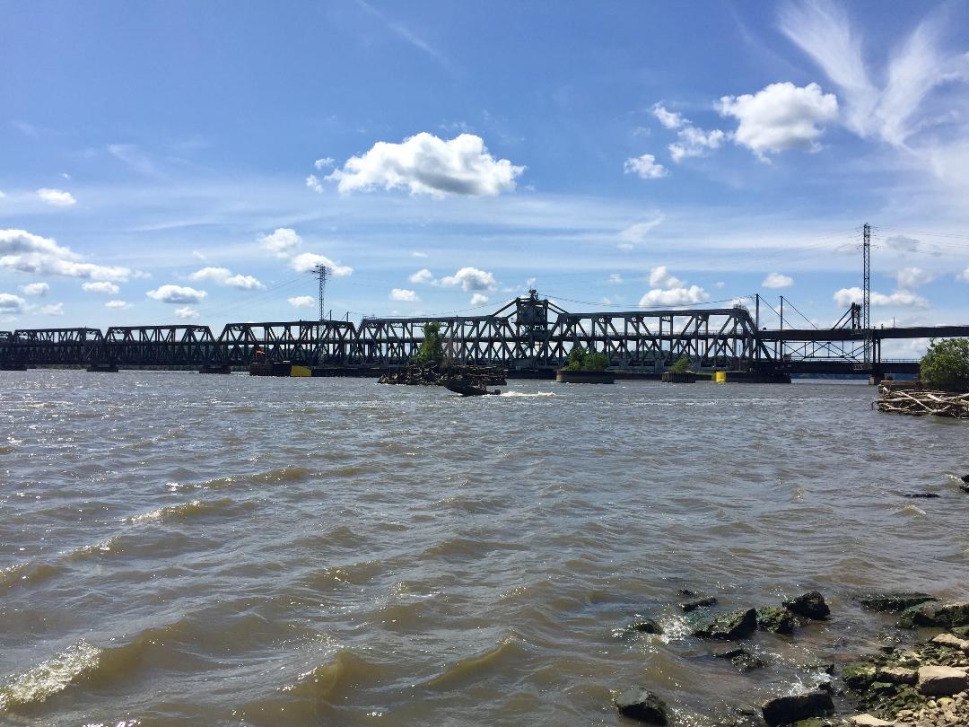
and walked right up to the lapping waves of the Mississippi River.  From that spot I had a great view of the Fort Madison Toll Bridge, which was completed in 1927.  To quote from Wikipedia - “The Fort Madison Toll Bridge (also known as the Santa Fe Swing Span Bridge for the old Santa Fe rail line) is a tolled, swinging truss bridge over the Mississippi River that connects Fort Madison, Iowa, and unincorporated Niota, Illinois. Rail traffic occupies the lower deck of the bridge, while two lanes of road traffic occupy the upper deck. The double-decker bridge, which is about a mile long with a swing span of 525 feet (160 m), was the longest and largest double-deck swing-span bridge in the world at the time it was built.”

I thought it would be cool to drive on the bridge, step foot in Illinois for a few minutes, and drive back to Fort Madison.  But when I initially passed the sign at the ramp to the bridge I thought I saw something about a width restriction of 8 feet.  Um, maybe I better not -- my overall truck camper width is 8 feet and height is just under 12 feet.  Checking online later I found this -- “As of 2018, the upper deck of the Fort Madison Toll Bridge is open to automobile traffic. It is closed to semi-trailer truck traffic.  The BNSF, which owns and maintains the bridge has posted the following limits: Gross weight posted as no more than 16,000 Pounds (8 Tons). Width: 8 Ft. Height: 14 Ft. 4 In. Length: 60 Feet."

The Mighty Mississippi.  Songs and stories have been written about the Mississippi River.  This river, when I see it, always conjures up images of “Mark Twain, Huck Finn, Tom Sawyer, Jim…”  I’d sure love to know, however, the stories the river could tell.  Not wanting to ignore the opportunity to do so, I squatted down on my haunches and put my hand out to touch, for the very first time, this enchanting river.

Moving on I then drove through a lovely neighborhood and parked on 9th Street, near the intersection with Avenue E.  At my right was the park Penny had told me about and there at the corner was the house where Penny grew up.  The house, built in 1888 and “…known around town as ‘The Castle’…” is truly magnificent.  An online search of Public Records indicates that this 2-story house has 14 rooms, eight of which are bedrooms, and Penny remembers the house as having five fireplaces and five bathrooms.  Penny gave me her blessing to include pictures of this house on my blog.

As seemed to be the norm of the young women of her generation, and probably especially in the rural Midwest, Penny did become a “farmer’s wife” and a cherished member of the Congdon family.  Penny hasn’t lived in Iowa for many years now but I think, having seen where she grew up, she will always be an Iowa girl at heart!

The Fort Madison Museum, my first stop.

The Fort Madison Toll Bridge…

…a train going through the lower deck.

Penny’s childhood home…


Taking Tony, Penny’s son, up on his recommendation, I had a delicious Tenderloin Sandwich lunch at the Buffalo Bar & Grille, located on the outskirts of town.  Just as I was paying for my meal I had an idea.  My camera doesn’t function anymore so I’ve been taking pictures with my iPhone and transmitting them to my email address to download on my laptop and sort out for my blogs.  The download process is successful when I have access to the internet.  However, I’ve been without that access for several days now.  If there’s a way to transfer photos directly from iPhone to laptop, without needing the internet, I have no idea how to do it.  So, anyway, I asked my server and she said “Sure, bring in your laptop…,” she set me up at corner table and gave me the restaurant’s password.  The downloading took about an hour (thank you so much, Debbie!), after which I returned to my site… my orange cone left untouched!

SUNDAY, AUGUST 25
By way of text the other day, Penny introduced me to Bonnie Congdon and Dot Drummond, who live just a few miles north of Fort Madison.  Bonnie is the younger sister of Glenn, the fellow Penny married years ago.  Although that marriage didn’t last, the entire Congdon family, including Bonnie, maintained their deep and heartfelt affection for Penny and continued to embrace and welcome her to family gatherings.  So, through the wonders of texting I accepted Bonnie and Dot’s invitation to visit them at their home this morning.

I found their lovely home with no problem, thanks to Dot’s texted directions, plus my GPS, plus the fact that Dot parked herself in her white minivan on the turn to their street and waited for me to appear on the horizon (there’s no missing my camper!).  We sat in their sunroom with our mugs of coffee and the first question Dot asked me was “How do you know Penny?”  “Through Darol,” I replied and from that point on the conversation flowed freely and we talked for two hours about a wide range of things.  Soon, I regretfully had to leave to get to my next destination, a three-hour drive from their home.

Saying good-bye to Bonnie I then followed Dot to see the house where Bonnie’s parents lived with their children.  As it is with the Atlee family, theirs is a story, a history, we can all appreciate.  Because, to some degree, whatever our individual backgrounds, it’s our story, too.

Behind me – Dot at the left and Bonnie at the right.
Around 3:15 p,m, after driving along on Rts. 61N, 34W, 218N, and I-80W, I arrived at the KOA in Newton, IA and got a site for tonight.  I’m planning to be here tomorrow as well…and get this Blog #5 posted!

Monday, August 19, 2019

SCENIC DRIVES

MONDAY, AUGUST 12
As I write this I’m waiting out a cloudy day - and rain is in the forecast – at the Twin Anchors Campground in Colo, IA.  I arrived here yesterday.

Last Saturday (10th), while I was still up in the Okoboji-“Iowa Great Lakes” region, clouds started to form.  By the time I got on the road at 8:30 a.m. the next morning (yesterday, Sunday) for the four-hour drive to Colo, it started to drizzle and it was like that, off and on, the entire way [my routes: Rts. 71N, 9E, 4S, 30E].  It was a good drive, regardless, and quite interesting to see miles of countryside - cornstalks, barns, livestock, and all - under a veil of mist, and, in some places, fog.

Colo is my starting point for a northward drive up one of Iowa’s scenic byways.  This RV Park, as far as I could determine, is the only one in this area, other than two state parks some miles back west.  After setting up my camper I went back to the office to access the internet (the signal doesn’t reach my site) and then walked around.  They have a fishing-swimming lake, Twin Anchors Lake, and a small petting zoo – goats, pigs, a pony, a donkey, rabbits (including seven babies), a few ducks, a turkey, some chickens, and three roosters.  I asked and, yes, roosters are allowed here – they can crow all they want.  Later, just as I sat down outside in my camp chair, the sun broke through, seemingly to promise that the next day (today) would be clear.

My chair, my book, a drink, the Twin Anchors Lake...
A flash woke me up this morning.  Looking out the window from my bed, the sky above the lake, and its reflection on the water, was a beautiful orange-red color, a sign of the coming sunrise.  What was that flash then, a dream?  No, not a dream…there was soon another and the sky turned gray.  Awww, a thunderstorm. The rain soon let up but the clouds remained.  Nope, I decided, I’m not gonna do that scenic drive today.  Back to the office I went to pay for today.

As the day wore on I filled my time with “internet” trips to the office, visits with the farm animals, some writing, some photo organizing on the iPad, and I finished the book I’d been reading.  I went to the office for the last time around 7:00 p.m. and on my walk along the lake’s edge back to my camper I saw this young guy doing something in the water.  My “neighbor” was watching him, too, so I asked what was going on.  He gestured (he knew I was Deaf) and said “big fish” - the guy had hooked a catfish, reeled it in, and was trying to pick it up from the water with his bare hands.  He succeeded and proudly walked it over to show the both of us.  Lordy, that thing is huge and obviously quite heavy!  After he took a picture of his catch he released the catfish back in the lake.  I asked my nice neighbor…“catch and release?”…and he said yes because then the catfish will grow even bigger.  Fascinating stuff!

The moon and its reflection.
TUESDAY, AUGUST 13
I woke up to dense fog.  The fog will lift…” I convinced myself and by the time I got back on [the newer four-lane] Rt. 30E the fog had indeed begun to dissipate.  Soon as I spotted the sign, I turned left and reached an historic junction – the Reed/Niland Corner – the spot where Rt. 65 meets the original two-lane Rt. 30.  Beginning in the 1920s the Reed/Niland Corner provided travelers with gas, food, and lodging.  Today, the restored complex is the only complete ‘one stop’ found in the entire length of the Lincoln or Jefferson Highway.

Rt. 30 - the Lincoln Highway - was formally dedicated as a memorial to President Abraham Lincoln in 1913 and runs coast-to-coast from Times Square (New York, NY) to Lincoln Park (San Francisco, CA), a total of 3,073 miles.  Click this link for information about Iowa’s section of the Lincoln Highway - https://www.lincolnhighwayassoc.org/info/ia/.  Completed in the 1920s, the Jefferson Highway is named after President Thomas Jefferson and runs from Winnipeg, Manitoba, Canada to New Orleans, LA.  That highway is Rt. 65 in Iowa and is designated one of Iowa’s scenic byways.  Information about the Iowa section can be found here - https://www.traveliowa.com/trails/jefferson-highway-heritage-byway/99/

Peering into the window of the gas station, I noted tires and service items (an old cash register, for example) that were just left in there.  The Niland Café was open for breakfast and they had pictures and other memorabilia inside.  The motel had a few guests, as ascertained not only by the cars out front but more definitely by this cute little boy gleefully riding his bike…still in his pajamas.

Reed/Niland Corner: Gas Station and Cafe.

From there I got on Rt. 65, the Jefferson Highway, and drove north towards the Clear Lake-Mason City area.  It was mostly cloudy during the drive, which significantly reduced much of the environmental colors of the countryside.  As before, I again noted that many farms had fields of a dark green crop adjacent to their cornfields.  What is THAT crop?  Thinking about it as I drove, I began to recall recent news reports (all true) about tariffs…China…agricultural products…Iowa farmers…corn and - SOYBEANS!  I Googled images of a soybean field and, yup, that’s what it is.  Something else I found online - “Iowa is known for having some of the world's most fertile soil. Farms make up about 92 percent of Iowa's land; only Nebraska has a higher percentage of farmland. About one-third of the best farmland in the United States is located in Iowa.”  You go, Iowa!

On the approach to Mason City I took Rt. 18W to I-35N to Clear Lake and then followed a set of directions to the Oakwood RV Park.  Compared to the RV Park I had just come from (in Colo), this place is spacious!  The other Park, right on Twin Anchors Lake, being that it is a popular weekend campground for returning families and friends, is jam-packed with RVs, about three fourths of which are permanent.  It was, when I arrived there, a bit of a tight squeeze for me to parallel park my camper directly behind a permanent motorhome and still leave space at the site behind me for whoever might arrive later (fortunately, no one did).  Fishing (catfish!) is the big thing there.  Here, at the Oakwood RV Park, the husband-wife hosts gave me the longest diagonal pull-through site I’ve ever seen, or been on.  I told the husband who escorted me to my site that they could easily fit four truck campers like mine on this one site!  In lieu of a lake here, I have a great view of a soybean field, just yards from my site.

It wasn’t quite noon when I arrived – and the sun was out - so I told the hosts that I was going to drive over to Mason City then will be back later.  Rather than reverse the directions I used to get here, I decided (both Jane, my classmate who lives in Maryland, and Greg, from back home, will be delighted about this!) to use the GPS on my iPhone to find my way to the Lime Creek Nature Center.  The area surrounding the center is 450 acres of mixed species of floodplain forest, ponds, and grassland.  The Winnebago River flows through there, too.  There are nearly nine miles of loop trails for hiking, biking, horseback riding, and cross-country skiing.  After looking around at the variety of mounted birds and animals in the Center I went for a 40-minute walk on their paved trail and, before leaving, admired an open field of wild grass and flowers.

Limestone rock wall formed as a seafloor between 420 & 360 million years ago.

The Winnebago River, through a grove of trees.
A wild field of flowers...and a butterfly...


Using the GPS again, I drove back to Clear Lake, so named for the beautiful large lake on which it is located.  There are a number of marinas around the lake, a state park, tourism-related businesses, and lots of people.  Returning to my site I sat outside for a long spell, enjoying the late afternoon sun, the cool breeze…and the soybean field right in front of me.

WEDNESDAY, AUGUST 14
Taking a driving break, I stayed put at the Oakwood RV Park today, updated my blog and did camper chores and other stuff.  Later in the day, considering that I’m now in the “Northeast Quad” of my Iowa trip, I reviewed my travel materials and notes for this section of the state.

It took me quite some time to determine my route for tomorrow because, wherever I am going at any time, I want to be sure about the proximity of RV accommodations in the vicinity.  I found a private RV Park that sounded good and, as I was well aware that tomorrow is the “Thursday” of the day before the start of the weekend, I tried to call to inquire about site availability.  The call didn’t work out so I sent an email…

THURSDAY, AUGUST 15
There was a reply this morning to the email I sent last night – they are full today through Sunday!  Dang it…but luckily, I’d prepared an alternate list last night so will just have to get going and take my chances.

“The Day the Music Died.”  This phrase is a reference to the day singer Buddy Holly died in a plane crash, on February 3, 1959.  Buddy’s last performance was here in Clear Lake, at the Surf Ballroom.  Not wanting to take his unheated bus to his next venue, many miles away, he chartered a small plane, which crashed minutes later in a snow-covered field, just a few miles north of Clear Lake.  Also killed were J.P. “The Big Bopper” Richardson, Ritchie Valens, and the young, inexperienced pilot, Rodger Peterson.  Following directions I drove up there, parked on the gravel road, found the path - marked by an oversized replica of Buddy’s trademark black glasses - and walked to the crash site where a memorial had been set up some years ago.  The well-beaten path, testimony to the volume of visitors over the years, divided that field for about a quarter mile – soybeans on one side and corn on the other.  Life goes on…

Replica of Buddy Holly's trademark black glasses, marking the path to the crash site.
The crash site...
...the memorial and mementos.

From there I got on I-35S and connected to Rt. 18E, which overlapped with Rt. 27S.  Somehow, driving through Charles City, I “lost” Rt. 18 and found myself heading south to Nashua on Rt. 27.  Checking my map real quick I watched for and then got on Rt. 346E which soon led me to Rt. 63N and then to Rt. 24E, my intended route.

My first “chance” destination was the Lake Meyer Park and Campground located between Fort Atkinson and Calmar.  Spotting the sign I turned left and drove on a long gravel road to the campground.  This is a self-pay-pick-your-site County Park, my first of this type on this Iowa trip.  It was about noon when I arrived and I found plenty of sites (with 30-amp electricity) to choose from.  None of the sites have a view of the lake itself but it’s a nice woodsy area -- lots of trees here.  Filling out the registration envelope, and deciding to make this place my “home base,” I inserted cash for a 3-night stay, departing on Sunday – the day the weekend ends!  I’ve got plans for tomorrow…and Saturday.

FRIDAY, AUGUST 16
Around 8:00 a.m. this morning I got the attention of Deb, the campground host, by standing outside her RV for a couple of minutes.  I wasn’t sure if it was too early to be knocking on her door so while I was having that debate with myself, she opened the door, stepped out in her barefeet and approached me.  She waved off my apology with a smile and said her dogs let her know somebody was out there.

I told Deb I was at Site #14…she knew that…and that I paid for three nights…she knew that, too…and I said I was leaving to which she said “WHY?”  I said, “No, no, I’m not leaving.  I’m just leaving for some time today and will be back later.”  I explained that because I will be driving around today - and tomorrow, too - in my truck camper my site will be vacant and I didn’t want to come back and find it taken by somebody else.  I responded that, yes, my registration slip is clasped to post #14 but I’d experienced somebody taking my “temporarily vacant” site once before and I don’t want that to happen again.  I told Deb that I was going to place my [brand new] orange collapsible traffic cone on my site as a deterrence.  She said that was fine and assured me she will make sure my site will still be there for me when I return.

Two of Iowa’s 14 scenic byways are located nearby: Driftless Area Scenic Byway and River Bluffs Scenic Byway.  Today’s pick, Driftless Area.  The “Byways Travel Guide” that I picked up the day I crossed into Iowa offers this description – “The most scenic byway in Iowa, the 144-mile Driftless Area Scenic Byway zigzags its way across the distinctive landscape of Allamakee and Winneshiek Counties in northeastern Iowa.

Zigzag is right!  And this certainly is a beautiful drive.  Highlights of my nearly 4-hour drive today –

* Since I was unable to find the local Visitors Center I didn’t have a detailed byway route map to use for reference along my drive.  The route diagram in the Byway publication is generic, but can still be somewhat helpful.  I told myself to just follow the Byway signs and pay attention to the location of the sun to make sure about my direction.  That second advice actually became moot around 11:00 a.m.

* The landscape here is rugged, a “…striking region of gashed and furrowed terrain…”  It’s hilly and the roads wind up and down these hills.  There are limestone bluffs, forested valleys, rivers and creeks, much of which offer hiking, fishing, camping, snowmobiling and other recreational activities.  There’s also a forest, the Yellow River State Forest.  And, oh yes, there are the acres and acres of farms and fields and livestock.

* On the approach to the town of Lansing I was driving parallel to what I first thought was a pond.  Seeing that the “pond” was still there as I drove on, I thought, no, that’s probably a river.  Here’s where a more detailed map of the byway would have been useful!  I then saw, on my right, a huge “Welcome to Iowa!” sign.  Glancing to my left I saw a bridge.  Then it hit me - that’s the Mississippi!  The sign was welcoming travelers crossing the Mississippi River from Wisconsin.

* The Mount Hosmer City Park, in Lansing, offers a panoramic view of the Mississippi River and surrounding area.  I decided to go see.  From the relatively level main road that I was on I turned right and found myself driving up a slight hill.  At the entrance to the city park I noticed, first, how narrow that entrance was.  Just past the entrance, and still driving slightly up, there was no missing the painted “10 mph” on the pavement.  Before I knew it, not more than three seconds later, after maneuvering a tight right turn I found myself staring up a steep road that ended I had no idea where…or when.  There was no way I could terminate that drive.  I couldn’t turn around and it would have been foolish, not to mention, dangerous, to try to back down.  I had no choice but to drive up a road that was not only steep but barely a lane and half wide.  I made it up to the overlook, thanks to adrenaline, determination, and probably a dash of Taurus stubbornness.  But, the credit isn’t all mine.  I may have been in control but I gotta hand it to the sheer power of my truck, itself heavy and further carrying the weight of my camper…plus me.  On the way back down I encountered only one upcoming car and that driver kindly made the move to “hug” her side of the road, stop, and let me pass her.  Oh, and yes, the view was spectacular.

* The zigzag route included drives on gravel roads.  Those roads brought me much closer to the farms…and in one place, to some cows that took an interest in me when I stopped to say “Hi.”  On the gravel roads, being the only one around, I could stop and take pictures.  That I couldn’t do on the paved roads because of other vehicles whizzing by and the lack of shoulders to pull off into.

Returning to my site shortly after 1:00 p.m., I had to smile with appreciation when I saw that Deb had placed a smaller traffic cone at the front of my site.  I’ll be sure and use it again tomorrow!  I set up the camper and was inside, with the screen door still open, when Deb pounded on the floor to get my attention.  This time I waved off her apology for startling me!  I thanked her, told her I had a great drive and will do the other byway tomorrow.  I kinda apologized for being “paranoid” about my site but she said she understood.  It’s almost 7:30 p.m. as I wrap this up and I see that more people have arrived.  Right, it’s Friday!

Pictures below from today’s drive -- 

The Mississippi River, seen from the Mount Hosmer City Park Overlook.

Driving through farmland on one of several gravel roads...

...and through a canopy of trees...

...and stopping to admire a patchwork of cornfields...

...and crossing a river through an old bridge.
SATURDAY, AUGUST 17
This morning I headed out to the second scenic byway I wanted to drive on – the 109-mile River Bluffs Scenic Byway.  Reviewing both the “Byways Travel Guide” and my Iowa map I decided not to drive the entire byway and to make route adjustments when it seemed most convenient for me.

The one POI (point of interest) I wanted to make time for was to visit the Effigy Mounds National Monument, just north of Marquette, IA.  I hadn’t researched this place so had no idea what it’s all about, other than the fact that it is right there, practically on the shore of the Mississippi River.  The ranger in the Visitors Center gave me their National Monument pamphlet and explained the trails that I could walk on.  I sat down to look at the pamphlet and it occurred to me that I didn’t know what “effigy” meant, as related to “mounds.”  “You coulda and you shoulda done your research, MAP, ole girl!

I asked the ranger what that word referred to. “Indian mounds,” she said.  I asked if they were natural.  “No, the Indians made them.”  “The Indians built the mounds?” Yes, she said.  Pulling out a book that was all about Indian mounds she further let me know that at one time there were 30,000 known mounds built by long-ago Indians, not only in Iowa but in Wisconsin and elsewhere.  I asked what happened to the mounds.  She replied: farming, progress, construction, development.  I looked at her and asked, “White man?”  These rangers get all sorts of questions but I think mine was unexpected.  She kept a straight face but I didn’t quite catch her reply…and I didn’t ask her to repeat it.  If the effigy mounds here are among a few left, we ALL have a responsibility to protect and preserve them.

To fully understand exactly what these effigy mounds are I went over to a display of aerial photographs.  The pictures showed the mounds in various shapes – conical, linear, compound, bear, and bird.  To quote from the pamphlet, “Effigy Mounds National Monument holds 206 known prehistoric mounds, 31 in the form of animal effigies.”  And this, “With basketloads of fill material, Effigy Mounds people in northeastern Iowa created a variety of animal shapes three to four feet high and up to 212 feet long.”

The pamphlet helped pinpoint the various mounds along the trail.  At the Little Bear and Great Bear Mound Groups I could see, at eye-level, raised earth, but, with no contrast in color to show an outline, it was quite challenging to make out the shapes.  Looking at an effigy mound of a bear, at different angles, I tried to visualize that that rise is the snout and that one is the front leg.  This mound is described as "...measures 137 feet long and 70 feet wide at the shoulder."  There were three burial mounds at a scenic view overlook of the Mississippi River.  I tried to take pictures but couldn't get a decent one of the bear effigy.  

This, I'm sure, is one of a cluster of conical mounds. "Conical mounds, round domes of earth, are the oldest and most numerous mounds in this area, dating back 2,500 years. They are 2 to 8 feet high and 10 to 20 feet in diameter....Ancient peoples in this region buried their dead in conical mounds..."

A group of three burial mounds.
After two hours at this wonderful and sacred place I got ready to move on, this time driving south on the Great River Road National Scenic Byway to the “small river town” of Guttenberg.  Located right on the shoreline of the Mississippi, it was interesting to see, as I made my right turn, the lovely houses that faced the river.  Further down the street were parks (and people were having picnics!) and the usual business fronts of stores, bars, and restaurants.  By then, considering the time and the distance, I took the quickest routes from Guttenberg back to my “home base.”  Those scenic byways, these last two days, were the perfect way to see this incredibly beautiful and historic part of Iowa!

SUNDAY, AUGUST 18
It had been mostly cloudy nearly every day this past week.  It didn’t rain during my two byway drives, fortunately (and thank you!), but then, around 3:00 a.m. this morning, lightning struck and the sky flashed incessantly for quite a long while.  It poured rain, too, but all my windows were closed and I was nice and dry.  I did have to hope the branches above my camper wouldn’t break and come crashing down.  If I’m writing this now, obviously they didn’t.

Having had no internet at this county park campground throughout my three-day stay, I decided to head down to the KOA in Waterloo, IA, via Rts. 24N, 150S, and 20W.  A major road construction, near where I was supposed to exit, temporarily threw me off but I arrived at the KOA in good time and got a nice site.  Time to post this blog…tomorrow…

The setting sun to the west and clouds in the east. (At the KOA in Waterloo, IA.)