MONDAY, OCTOBER 21
Today is my
Mom’s birthday. Had she lived she’d be
98. I’ve observed both parents’
birthdays during this 3-month trip. I
arrived in Iowa on August 1, Dad’s birthday, and today I’m in Arizona. When I started traveling in the truck camper
in 2006 both Mom and Dad had already passed on.
I often wonder what they would think, how they would react, if they were
reading my blogs. They might worry, as
parents are prone to do, even when their children are middle-age adults. But I think, since we were a “nomadic”
family, Dad being in the Navy, they would reminisce about their own road
travels as we moved around and went on family vacations. Anyways, here’s to you, Mom!
Last night (Sunday) was my second night at the Sonora
Rancho RV Park and Inn, near Florence, AZ.
After posting Blog #13 around 3:30 p.m. I decided to check out the
swimming pool. Although I knew the pool
wasn’t heated I was not prepared for how cold the water was – 68 degrees,
according to the pool thermostat! The jump-in-quick-and-get-it-over-with strategy
doesn’t work with me so I immersed myself in the water v-e-r-y slowly until I
finally was ready to dunk my head. Ah,
nice! Then I went to the hot tub – 15
minutes in that 100 degree water, directly from the pool was blissful. There was nobody else around. The folks who stayed at the inn had left and
the RV snowbirds haven’t arrived in droves yet.
So, this
morning, with my next destination about an hour’s drive away, I simply
relaxed and took my time getting ready to leave. On my way at noon I got back on Rt. 79 and
drove north to Florence, got fuel, and then from there the highway took me
through the desert to Florence Junction where I then got on Rt. 60W. This four-lane highway became a bit more
congested as I approached and took an exit towards Apache Junction. Following the signs I got on Rt. 88E and soon
arrived at the Lost Dutchman State Park, located at the base of the Superstition
Mountains. From Wikipedia -
“The Superstition
Mountains (Yavapai: Wi:kchsawa), popularly called ‘The Superstitions’ is a range of mountains in Arizona located to the east
of the Phoenix
metropolitan area. They are anchored
by Superstition Mountain, a large mountain that is a popular recreation
destination for residents of the Phoenix,
Arizona area.”
“The Lost Dutchman's Gold Mine (also
known by similar names) is, according to legend, a rich gold mine hidden in the southwestern United States. The location is generally believed to be in the Superstition Mountains, near Apache Junction,
east of Phoenix, Arizona. There have been many stories about how to find the
mine, and each year people search for the mine. Some have died on the search.”
“The mine is named
after German immigrant Jacob Waltz
(c. 1810–1891), who
purportedly discovered it in the 19th century and kept its location a secret.
Before the unification of Germany, the demonym "Dutch" was used for people from the Netherlands and Germans alike."
From my reserved pull-through
loop campsite, and through my dinette slide-out windows, I have a great view of
the picturesque rugged cliff of Superstition Mountain. Around late afternoon I took a walk and
marveled at the colors the setting sun cast on the cliff. The bright orange sun slowly dipped behind
saguaro and other desert plants while I was still on my walk. Soon as I made it back to the camper I kept
the rear door open and stood there watching the band of sky at the western
horizon gradually change color from orange to dark orange to red to a darker
red and finally fading out to a darkened sky.
 |
From my
loop site this is the view of the rugged cliff of
Superstition
Mountain.
|
 |
I noticed
this clearing as I was walking around the campground just before the sun
set.
The colors
caught my eye, the two trees framing the cliff in the background, and the way
the yellow
strands of grass intermingled with the rocks.
Fortunately, I was able to get my
shadow out
of the way!
|
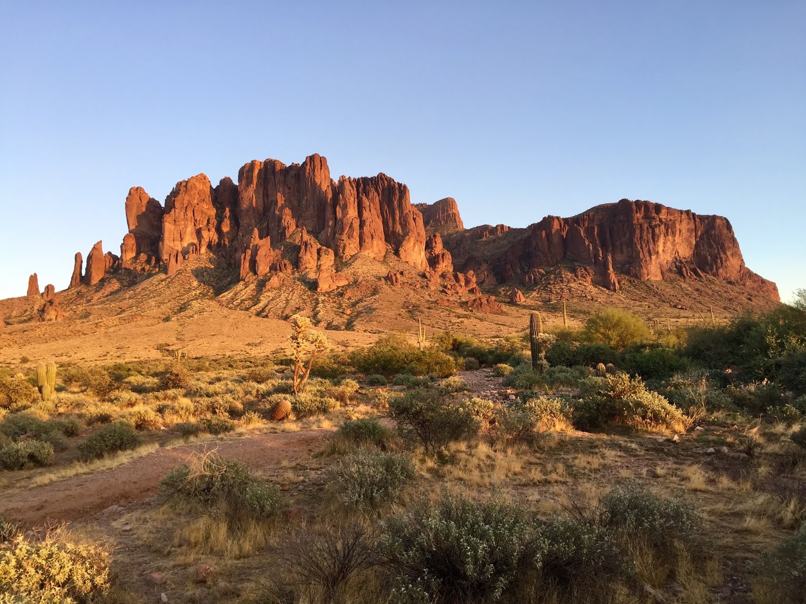 |
Superstition
Mountain just before sunset.
|

TUESDAY, OCTOBER
22
The sun
had already risen when I woke up but I couldn’t tell because the sun was
blocked by the commanding height of the Superstition Mountain. I stepped outside and, looking up at this
majestic and revered cliff, I waited…I waited for the sun to rise a little
higher and make its appearance between the jagged rocks at the top of the mountain. It took millions of years for this mountain
to form and the sun, for eons, has risen at that same jagged edge. Keeps me humble…
This
being an unexpected extra week of travel, I decided I would just spend my time
in relaxation mode. Right outside the driver
side of my camper (no slideout) is a sandy clearing with scattered rocks, some small
cacti, and other dense shrubbery. It was
shady on that side so I sat out there with my book and observed the Gambel’s
Quails and other desert birds going about their morning activites. The Gambel’s, with the plumes on their heads,
are entertaining to watch. They can fly
but they prefer to run…and they sure do run fast on those little legs. Movement of other critters that caught my eye
included lizards, a chipmunk, and a couple of rabbits.
Around
3:00 p.m. I took a 25-minute walk on a nearby interpretative trail. Turning around to head back to my campground
I encountered a middle-aged husband/wife couple who were the exact replica of
each other -- long pants, light blue long-sleeved shirts, wide brimmed hats,
and carrying long-lens digital cameras.
When I realized they were speaking to me I let them know I was
Deaf. The lady, bless her heart, started
to flap her arms to tell me they were looking for birds to photograph. I asked them if they were at site #45,
directly across from me, because I had noticed earlier that the fellow at that
site had a long-lens camera. No, they’re
at a different campground. I admired
their cameras and cracked a little joke about doing my best with my little
iPhone.
Sitting outside again, observing, again,
the colors of the setting sun on the cliff, I saw this same couple – no
mistaking their identical outfits - walking towards me. I did the two-arm wave and they waved
back. I think they actually looked for
me at my site to show me the incredible pictures they had taken today. The lady showed me other pictures she took
elsewhere, including a series of continuous auto shots of a hawk, in Florida,
snatching a water bird from the water and flying off with it in its talons. I was amazed at the details in her photos,
not to mention the look on that poor bird’s face. They said they easily take hundreds of
pictures in one day, go through hours of a deletion process, and save and
identify/record the pictures they keep.
I wanted to learn more but the sun had set and they needed to walk back
to their campground. Gosh, RV folks, no
matter how fleeting the encounter, are the most fascinating and the best people
we can hope to meet!
 |
The
morning sun, working its way up and above Superstition Mountain…
|
 |
…and
shining upon my truck camper.
|
 |
The scene
from my walk on the trail.
|
 |
Another
sunset scene on this, my second evening at Lost
Dutchman
State Park – my last state park of the trip.
|
 |
Good
night!
|
WEDNESDAY, OCTOBER 23
Whether or not there’s gold here in the vicinity of
the Superstition Mountains, I found myself $11.00 richer early this morning
when I spotted a $10 and a $1 on the ground near the restroom facility. Seeing nobody around who might have lost
those bills I put them in my pocket, returned to the camper, and got ready to
leave.
Inasmuch as I’ve been looking forward to
going home I am so very glad I spent two days at this state park. Totally unexpected because of the extra
travel week, this is now definitely the last state park of my journey. I got back on Rt. 60W, drove through a part
of Phoenix on Rt. 87S, connected to I-10E and arrived at the Las Colinas RV
Park near Eloy/Casa Grande, AZ. Moving
on tomorrow…
THURSDAY,
OCTOBER 24
The drive to my next
destination, Salome, AZ, took less than three hours. To bypass the I-10 that goes through Phoenix
I took I-8W and then connected to I-10W by way of Rt. 85N. Taking Exit 81 I turned northwest on Salome
Rd., a 30-mile two-lane road through the desert that turned out to be, because
of the many dips on the road, quite fun to drive on. There were many posted caution signs along
the road with two messages: to not drive on the road when it is flooded,
especially at those dips; and, since it was “open range” at my right, to watch
for cattle. They even painted on the
pavement, in large block letters, “Watch for Cattle” (and “Watch for Cows” when
I crossed into the next county).
Salome, a small
unincorporated community, is located within the Sonoran Desert “…in the beautiful Mc Mullen Valley, between
the Harquahala and Harcuvar Mountain Ranges on Hwy 60 between Wickenburg and
Quartzsite.” There are several RV
Resorts, including a KOA, in this area and the KOA is my home for today and
tomorrow. This KOA has over 100 RV sites
but most of those sites are empty. Won’t
be long, though, before the place is bustling with snowbirds and winter RV
travelers.
After setting up the camper at my
reserved site I went inside the clubhouse to look around. The manager, when I registered, told me that
they have a TV in the clubhouse and another one in the nearby game room and
both buildings are open 24 hours for KOA guests. That information prompted me to inquire about
the closed captions and he said I was welcome to use the remote and turn them
on. There were two people in the
clubhouse when I went in and as I greeted them I looked up at the TV and was
surprised to see the captions already on.
The lady told me that the manager had just stopped in and activated the
captions “…for you,” she said. I checked later and found the captions were
also activated on the other TV. I made
sure to go back to the office and thanked the manager for doing that for me.
This lady in the clubroom, in her mid-70s maybe, had helped
spot me as I backed the truck camper into my site. She knew already at that point I was Deaf (because
of the captions) so here in the clubhouse we introduced ourselves. Jan then, catching me by surprise, asked if I
liked spaghetti. To make sure I got that
right I repeated “Spaghetti?” She accompanied her smile with a nod of her
head. Kinda figuring out the purpose of
her question I replied “Um, now and then.” And then it came. She was making spaghetti for dinner and
invited me to join her and James (the other person in the room) and several
other people, here in the clubroom at 6:30.
Feeling a little awkward now, but wanting to be as honest and gracious
as I could, I told her communication would be problematic for me. She surprised me again when she said “But, you still have to eat.” I smiled at that, thanked her for the kind
invitation, shook my head a little bit, and left it at that. She did ask again later in the day and when I
again declined we then changed the subject and I learned that she lives in
Alaska and will spend the winter months here at the KOA. The social life of snowbirds! No doubt this KOA will see lots of spaghetti
dinners, potlucks, pancake breakfasts, pool parties, and the like until spring!
Before going to bed I went back to the game room,
which is also a library, to check out the TV there. The TV was on but nobody was in the
room. The remote was on the table and
the list of channels (gosh, they have a lot of channels!) was posted on the
wall. I found and changed the channel to
CNN and watched for a little while. From
there I went to the now empty clubhouse and changed the channel on that TV to
CNN. Come morning, let’s see what’s
airing on both TVs.
FRIDAY, OCTOBER 25
After
watching the sun rise from the cabover window, I got up and took a walk around
the perimeter of this very nice and spacious KOA. I went inside the game room and saw that CNN
was still on. Oh, the funeral service
for the Honorable Rep. Elijah Cummings was happening - I sat down to watch that
for a short while. At the clubhouse the
channel had been changed to Fox News.
Alrighty, since I think the game room isn’t used much by the folks
currently here, it will be my go-to “TV space.”
Today was
a nice day, nothing but a cloudless blue sky and warm temps. In full “relaxation mode” I did some updating
on the laptop, then spent some time with my book at the pool/spa, then went to
my unoccupied “go-to” for an hour, then sat outside checking stuff on my iPad,
then had a salad for supper. Moving on
tomorrow…
SATURDAY,
OCTOBER 26
Seeing me
prepare the camper for departure Jan came by to say good-bye. She reached out to give me a hug and I took
this opportunity to thank her again for the dinner invitation and to wish her a
pleasant winter’s stay. Such a nice
lady!
On my way just before 11:00 a.m. I took Rt.
60W to Quartzsite [AZ], connected to I-10W, crossed the Colorado River into California,
and made my way to the Hidden Beaches River Resort in Blythe. This RV Park is situated on a slight rise
above the Colorado River and, from my windows, I can see a portion of the
river. I walked down to the small beach
section and thought to myself – “Well,
MAPPIE, you didn’t plan this but you’ve come full circle.” My first night in the camper, on July 21st,
was at the Cattail Cove State Park in Arizona, situated right at the Colorado
River. And here, on the California side
of the Colorado River, I’m spending my last two nights in the camper.
Tomorrow, Sunday, I will be bagging up everything that
has sustained me inside and around the camper throughout this three month
journey.
Monday morning I will dump the black,
grey, and water tanks – the final essential camper task of all – and go home.
Tuesday morning I will take the camper back to Galaxy
Campers, in Ontario, CA, for storage.
There it will remain until……..
JOURNEY
TO THE MIDWEST - IOWA & KANSAS (July 21-October 28, 2019)
From Palm Springs to
Iowa (via CA-AZ-UT-CO-NE) -
July 21-31 (11 days)
Total miles: 1,775 (approx.)
Travel around Iowa -
Aug 1-Sept 3 (34 days)
Total miles: 2,000
(approx.)
Driving through
Missouri to Kansas -
Sept 4 (1 overnight)
Total miles: 350
(approx.)
Travel around Kansas -
Sept 5-Oct 6 (32 days)
Total miles: 1,750
(approx.)
Travel to Palm Springs
through the Southwest (via OK-TX-NM-AZ-CA) -
Oct 7-28 (22 days)
Total miles: 1,686 (approx.)
Total Days of Travel: 100
Total
Miles of Travel: 7,561 (based on start/end odometer readings)