Friday, September 6, 2013

From Lakes to Mountains --What a Trip!

SATURDAY, AUGUST 24
Our cruise around the Apostle Islands yesterday [in Bayfield, WI] was my last significant time spent on Lake Superior.  As Helena and I exited the Bayfield Peninsula, via Rt. 13 S and CR-H, the contours of the land diminished the lake’s visibility from the road.  Realizing this as I drove on, I pretty much bid good-bye to the Great Lakes I had visited on this trip. 

We eventually connected to Rt. 53 N and got a site for two nights at the Northland Camping and RV Park, near Superior, WI.  As soon as we got the camper set up, I got right to work on my 10th blog of the trip.  As I worked, Helena sat outside with her book, enjoying the gentle breeze – and rare bug-free atmosphere!

The next day, Sunday 25th, I posted my blog and we both did laundry.  Saturday’s cool breeze was replaced by warm and humid air.  The RV Park had a pool and I took advantage of that while Helena stayed cool inside the air-conditioned camper.  We start driving west tomorrow, Monday…   

MONDAY, AUGUST 26
Due to the humidity of the day before, we agreed to leave the AC on in the camper during the night.  In doing so, and since I had never left the AC on overnight on previous trips, I learned something new.  Up on my cabover bed, every time the AC kicked on, the cold air blasted right at me, jerking me awake every time!  Unable to close or adjust the vent that aimed directly towards the bed, I had no recourse but to turn the AC off.  Back in bed, I noticed flashes of bright light in the distance.  When the storm passed overhead, those flashes of lightning startled me awake.  I think Helena slept peacefully on the dinette bed.

By 8:30 a.m. this morning, we were on our way.  Taking Rt. 2 W, we left Superior, WI and crossed into Minnesota, driving clear across the state for about five hours.  We made it into North Dakota and stopped at the Grand Forks Campground in Grand Forks.

TUESDAY, AUGUST 27 - Today we drove all day, on Rt. 2 W, from Grand Forks to Williston, ND.  In Minot, we stopped to stretch our legs and get groceries and gas.  North Dakota is mostly flat but it was a good drive otherwise.  In the Williston area we got a site at the Lewis and Clark State Park.  We walked over to the nearby Lake Sakakawea and got our feet wet for a few minutes.

WEDNESDAY, AUGUST 28Back on Rt. 2 W we drove for nearly seven hours to Havre, Montana – and Mountain Time.  It was a hot day and some road construction along the way slowed us down a bit here and there.  We went to a RV Park outside of town, but finding the office locked and nobody in sight, we left and went to the Havre RV Park in town instead.

THURSDAY, AUGUST 29 – Still on Rt. 2 W, we stopped for breakfast in Shelby, MT.  From there we got on I-15 N and reached the border with Alberta, Canada.  The Canadian official asked the usual questions, one of which was, “Are you going to leave anything in Canada?”  To which I replied, “Ummm, uhhh, human waste.”  He laughed and waved me through.  Crossing over we then took Routes 4 N, 2 N, and 3 W to Fort MacLeod where we got a site at the Daisy May Campground.  Even though we’re in Canada, tomorrow is the beginning of the [USA] Labor Day Weekend and, as we’re headed for the extremely popular Banff National Park, we’re hopeful we will not have problems finding a place to stay in the area. 

FRIDAY, AUGUST 30
Despite a rather fitful night (blame it on the tuna fish salad from the grocery store), I managed to get up by 6:30 a.m. so we could leave by 7:30 a.m.  It’s about a three-hour drive to Calgary, Alberta and we were well on our way as soon as we got on Rt. 2 N.

On the approach to Calgary, Helena and I kept a lookout for Rt. 1 – the Trans-Canada Highway.  When we spotted the sign, we discovered that it was rather small and the “1” was hard to see.  We also discovered that skirting around downtown Calgary – in traffic - was no easy feat!  We had to pay close attention so as not to miss the teeny sign as we maneuvered through and around many turns, exits, and traffic lights.       

After about 20 minutes of this we finally reached open country and the drive became less hectic.  Just before we reached the Banff National Park we stopped at a Husky gas station and bought a day pass for entrance into the National Park.  Helena had read about this “advance purchase” tip the day before and with the pass on my windshield we took the bypass lane into Banff.

Approaching Banff National Park, Alberta, Canada. 
Photo by Helena.

Finding a place to park in the Village of Banff we went to the Visitors Center to get information about campgrounds.  The nice gentleman who assisted us advised that our first choice campground [with electricity] was full.  When I told him electricity wasn’t important, he then suggested we go to the Johnston Canyon Campground, located off of Rt. 1A and situated midway between the Villages of Banff and Lake Louise.  We got there within 20 minutes and secured a really nice site nestled among tall, skinny pine trees.  Those trees were so tall they practically blocked the sunlight. 

We didn’t have much sunlight anyway, being that it was cloudy and cool and it rained off and on.  Still feeling somewhat out of sorts after my restless night, I was content to just stay in the camper…and Helena was just as happy to comply.  With no hookups here, we were fine with propane for the refrigerator-stove-heater and battery power for the interior lights.  After resting for a short while and watching the comings and goings of fellow campers, we played a game of Scrabble on my travel board.  Helena then prepared tomato soup (with milk!) for our supper – the perfect antidote for my tummy. 

SATURDAY, AUGUST 31
Prior to going to bed the night before, I turned the heater off.  My bladder woke me up around 4:30 a.m. and when I threw off the covers, I immediately felt the chill inside the camper.  You silly girl, Mapita, we ARE up in the woods of the Canadian Rockies and the nights up here ARE going to be chilly, so turn the dang heat back on!

Ready to start our day, Helena and I first stopped at the registration office around 9:00 a.m. and paid for a second night at this campground.  Good thing we did this before the 11:00 a.m. re-registration deadline because when we returned later in the afternoon the “FULL” sign was out.

Our plan was to visit Lake Louise first thing this morning.  Our reference materials advised that visitors to Lake Louise should arrive there before 11:00 a.m. and after 5:00 p.m.  No reason was stated and I thought maybe the recommendation had to do with the position of the sun upon the lake.  Because I decided to take a slight detour to a Ski/Gondola tour area (where we found a Starbucks in the lodge) we didn’t get to Lake Louise until shortly after 11:00 a.m.  My goodness - we could not find a place to park!  The area was jam-packed with cars, RVs, tour buses, people!  It was a beautiful morning but we just could not park anywhere.  Let’s come back tomorrow morning, I suggested, just before we head on to British Columbia.  That decided, we drove back towards the Village of Banff to check out several scenic drives in that area – the Lake Minnewanka Loop, Tunnel Mountain, and the Vermilion Lakes.  See our photos below…


Banff National Park.  Photo by Helena.
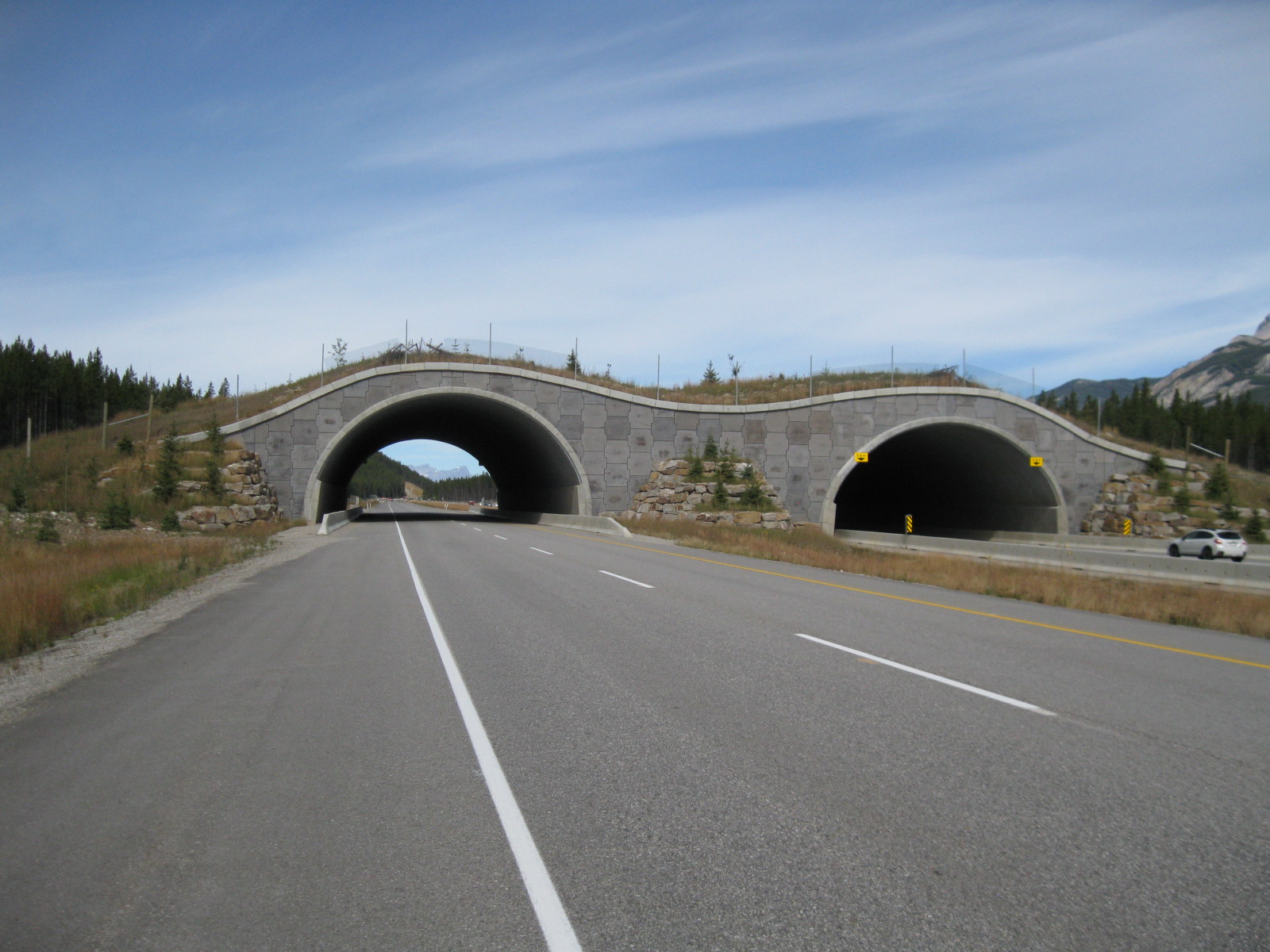
Banff National Park has several of these overpasses on the Trans-Canada Highway.  They were constructed, not for vehicles or people, but for the wildlife!  Note the fence along the arches.
Photo by Helena.


Helena took this photo of me checking out Lake Minnewanka. 


While enjoying our Tunnel Mountain scenic drive, we checked out these hoodoos (foreground).
 

Visiting Vermilion Lakes, we admired the unique rocky formation of Mt. Rundle.  This is a popular site for photographers and artists. 

SUNDAY, SEPTEMBER 1
Up early, fully dressed, and raring to go, Helena woke me up at the unholy hour of 6:00 a.m.  Slow to fully wake up, the sight of the crisp blue sky through the camper’s windows soon quickened my pace and we were off by 7:15 a.m. to go see Lake Louise.  Hints of the sunrise were bouncing off the rocky peaks of Banff National Park.  We were lucky to be granted the promise of a truly gorgeous morning. 

There were other early risers at Lake Louise but parking was plentiful.  Towered and dammed by the rocks of an ancient glacier, the green water of Lake Louise was calm and serene.  The shadows on the lake – as well as the glacier’s reflection on the water – constantly changed as the sun rose above the peaks and pine trees behind us.  We walked over to the Chateau Lake Louise and the Concierge there told us about a [2.8 mile roundtrip] uphill trail to the Fairview Lookout.  We also learned from her that the color of the lake’s water changes every two hours.  This may explain why the place is swarmed by visitors between 11:00 a.m. and 5:00 p.m.  We took the trail through the woods up to the lookout and the view up there was really nice.  
   

Lake Louise at sunrise - beautiful and inspiring.
Photo by Helena.

We hiked on the Fairview Lookout Trail.  It was uphill all the way and I needed to stop now and then to catch my breath.  I think Helena was happy to stop, too -- to wait for me to continue.

From the Fairview Lookout we had a great view of Lake Louise, the Chateau Lake Louise, and surrounding mountain peaks.

We wanted to see Moraine Lake, too, but after a beautiful drive up the winding road, we found the parking lot there full.  No matter, we came away feeling we saw a lot of the beautiful Banff National Park scenery.

Beautiful Banff National Park!  Not a bad looking truck camper either! 
 Photo by Helena.

Continuing on the Trans-Canada Highway, through the beautiful Canadian Rockies, we soon crossed into British Columbia…and Pacific Time.  We reached Sicamous, BC around mid-afternoon and stopped at the Sicamous KOA.

MONDAY, SEPTEMBER 2
On our way by 8:00 a.m., we took Rt. 97A to Rt. 97 S and found this to be a lovely drive following the contours of a winding lake.  There were also many groves of fruit orchards and fruit stands along the way.  At Osoyoos, following a brief visit inside my camper by a U.S. Customs official, we crossed the border into Washington, USA!

Washington’s display of apple and other fruit orchards, lakes, rivers, gentle and rugged hills and mountains, was just as lovely as we continued our drive on Rt. 97 S towards Leavenworth.  We stopped for the night at the Thousand Trails RV Resort, near the community of Plain, WA.  This was our last night in the camper.  

TUESDAY, SEPTEMBER 3
Taking Rt. 97 S to I-90 W [towards Seattle], we took the Tacoma Narrow Bridge across Puget Sound and arrived at Lisa’s beautiful log house on Lake Wooten.  Turning off the truck’s engine, right then and there, officially concluded my “Great Lakes Camper Adventures.”  Lisa came out holding my cat, AJ, and not far behind was Navidad, my other cat.  It sure was good to see the three of them.  A fantastic trip this was and I very much enjoyed sharing a portion of it with my good friend Helena.  She returns home to Maryland on Saturday.  On Sunday the kitties and I start the 3-day drive back home to Palm Springs.   

GREAT LAKES TRIP (June 8–September 3)
Total Travel Days  - 88
Total Miles             - 9,747
Total Gallons         - 825
Total Fuel               - $3,377.53
Total RV Parks       - $2,727.93
Total Food              - $776.00

NOTE: Computation for six days of travel between California and Washington is not included in above figures.

Sunday, August 25, 2013

Boat Rides and Other Modes of Transportation.


TUESDAY, AUGUST 20
Helena woke me up at 5:30 a.m. on Monday 19th so we could catch the sunrise on Lake Michigan [at Kleinke Park].  After uploading the pictures to my laptop we had coffee and breakfast and then left at 8:15 a.m.  It’s a good thing we left at that time because I completely forgot that we were going to lose an hour somewhere in Michigan along the way to St. Ignace.   

From Rt. 35 N we got on Rt. 2 E and about three hours later we had ourselves a site, with a nice view of Lake Michigan, at the Lakeshore RV Park, in St. Ignace.  After setting up the camper, I immediately connected to the Wi-Fi and posted Blog #9.  That done, Helena and I walked down to the rocky beach to check out Lake Michigan and the view of Mackinac Bridge.  Completed in 1957, the famous and impressive Mackinac Bridge is an 8,614-foot suspension bridge that spans the Straits of Mackinac to connect Michigan’s Upper and Lower Peninsulas.  Driving north on the bridge, Lake Michigan is to the left and Lake Huron the right.  The weather was absolutely lovely today – sunny with a pleasantly cool breeze.  We sat outside and made the most of it!

At 9:00 a.m. this morning (Tuesday) we took a free shuttle, courtesy of the RV Park, to a ferry dock to catch the 9:30 a.m. Shepler’s Ferry to Mackinac Island.  Here’s what we did today –

Limited to only three morning “Mighty Mac” departure times from St. Ignace, our ferry went right under the Mackinac Bridge on the way to Mackinac Island.  The close up view of the bridge from that vantage point was quite awesome to see.  Photo by Helena. 

The first thing we decided to do when we got on the island was to rent bikes!  It’s been years since I rode a bicycle and I felt like a clumsy oaf when we took off.  Fortunately, my “pedal power” memory kicked in…as did my sense of balance!  Photo by Helena. 


We biked on the M-185 Perimeter Tour – the “only highway in America where no cars are allowed.”  Motorized vehicles have been banned on the island since 1898 and our 8.5-mile bike ride around Mackinac Island’s shoreline took us “…right between dramatic forestry and the rocky shores of Lake Michigan and Lake Huron with majestic views of their deep blue waters.”  All transportation on the island is by foot, bike, and horse-drawn carriage or taxi.  Horse-drawn drays are used to deliver loads of food, beverages, and general supplies.  Luggage is delivered by bike or wagon.  Workers bike around the streets and scoop up horse droppings into a metal basket attached to the bike.  Photo by Helena.   


Helena, pointing out the “majestic view” of Lake Huron!  Mackinac Island is on Lake Huron, northeast of Mackinac Bridge.  The town center is on the southern end of the island.  When we started our bike loop, we went counter clockwise for 8.5 miles back to town.


Helena and I stopped several times along the way.  A nice fellow took this photo.  There were lots of seagulls on the rocks and in the water.  A flock is taking off directly behind us.


This is Arch Rock, along the bike loop.  To get up there, you have to take a different bike trail.  Photo by Helena.


Our journey on the bike loop took us a little over two hours.  We returned the bikes and then walked around town a little bit, checking out the stores and purchasing a thing or two.  We then took a horse-drawn carriage tour with another couple to see other points of interest on Mackinac Island.  This is the Grand Hotel, one of the largest and most visible landmarks on the island.  It opened in 1887 and has the longest colonial porch in the world.


The Grand Hotel’s porch.


The driver stopped the horses at the top of a bluff so we could take in the view of the harbor and the town.  At the end of the tour, I asked what kind of horses these were.  Belgian,” was the reply.      


A section of the town center.  The ferry dock is nearby.  We got an early dinner and then took the 5:30 p.m. ferry back to St. Ignace.  Photo by Helena.


WEDNESDAY, AUGUST 21
I had asked Helena the night before to be sure I’m up by 7:00 a.m. this morning so we could be on our way by 9:00 a.m.  When the smell of coffee didn’t make me stir, Helena, noticing that I had one leg outside my blanket, resorted to waking me up with a very slight tickle to my foot.  That got me up pretty quick! 

Over our breakfast of cereal, Helena gestured towards the dinette window and asked me if I noticed anything.  I looked outside and said – “Nice morning? The sun?”  She kept gesturing around the window.  Then I saw it!  Or rather, I didn’t see it!  No dowel!  The little stick was gone!  The pleated shades were up!  While I had been taking forever to wake up that morning, she studied the strings for the pleated shades, figured out how they were supposed to work, and fixed them.  When I attempted to lower/raise the shades later, they were tight – exactly how they are supposed to be – and it took me a while to get used to the new feel.  THANK YOU, HELENA!

We took I-75 N to the Rt. 123 scenic loop.  The drive took us to the northern shoreline of Michigan’s Upper Peninsula where, in the town of Paradise, we could see Lake Superior.  The route then turned southward and we were driving through a forest of trees dotted with ponds and marshes.  We stopped for about an hour at the Tahquamenon Falls State Park to stretch our legs and check out the Lower Falls.

Lower Tahquamenon Falls, Tahquamenon Falls State Park, along Rt. 123.

We soon got on Rt. 28 W towards Munising and got a site at the City of Munising Tourist Park.  As it had been a little bit humid that day, I decided to take a dip in the refreshingly cool water of Lake Superior.  Back at the camper and sitting at the dinette table with Helena, we noticed dark clouds forming.  And then it poured!  We quickly closed all the windows and watched the downpour.  Eventually the rain let up and the sky cleared just enough to grant us all a very nice sunset.

Sunset following a rainstorm, City of Munising Tourist Park, Munising, MI.


THURSDAY, AUGUST 22
The day started off cloudy, with the threat of a few more sprinkles, but it became clear and sunny as we drove on Rt. 28 W looking to get on Rt. 41 N.  Making the connection, we were now on the Keweenaw Peninsula, the westernmost peninsula on Michigan’s Upper Peninsula. 

We stopped first at the McLain State Park, off of Rt. 203 near Calumet, to get a site for tonight.  That done, we then left to drive north on a woodsy and winding narrow two-lane Rt. 41 to Copper Harbor, at the tip of the peninsula.  Located here is the Fort Wilkins Historical State Park.

Copper was discovered in this area in the 1830s, resulting in a copper rush and the establishment of mining operations in the region.  The U.S. government established Fort Wilkins to help maintain order and to provide aid for shipping on Lake Superior.  The fort was eventually abandoned and the buildings on the site were used for other purposes before they fell into disrepair.  The structures on the grounds today were carefully reconstructed based on photographs and archaeological excavations.

After walking around, and checking out the nearby Copper Harbor Lighthouse, we got supper in town and then took an equally scenic Rt. 26 back to our campsite.  The sunset down Lake Superior was one big ball of orange!

Reconstructed buildings - Barracks (foreground); Kitchen and Mess Room (background).  Behind the flagpole is Lake Fanny Hooe.

Reconstructed buildings - Barracks (left); Kitchen and Mess Room (right). 
Photo by Helena.

Reconstructed buildings - Barracks (left); the two structures on the right are the Officers' Quarters.

The Copper Harbor Lighthouse, near Fort Wilkins.
 

FRIDAY, AUGUST 23
We left the McLain State Park around 8:15 a.m. and took Rt. 203 to Hancock where I got gas.  Spotting a McDonald’s, we stopped there for coffee and to use their hotspot. 

It was another lovely morning, which made for an equally lovely drive.  Most attentive to her duties as navigator, Helena kept me on track along Routes 26 S, 45 S, 28 W, and 2 W – into Wisconsin!  Ahead by an hour now, we made good progress, via Rt. 13 N, to the town of Bayfield, on the Bayfield Peninsula.  Bayfield, a small community with a marina, shops, restaurants, and bars, is known mostly for being “…home to the Apostle Islands National Lakeshore, a beautiful archipelago of enchanting islands.”

At the Visitors Center we picked up information on cruise tours around the Apostle Islands and while we were there we also discovered that only one RV Park, not our first choice, was the only one with available spaces.  The lady in the office cautioned that it was really busy in the area.  Helena and I also noted that today was Friday.  I asked the lady if she could do me a favor and call that RV Park and ask them if they could hold a site for us.  She gladly made the call and they were just as happy to comply.

Back in the truck we drove to the dock and found the cruise ticket office.  Best we go and pay for our site first at the Apostle Islands Area Campground, just off CR-J, and then come back to town.  The owner at the campground was real friendly and accommodating.  He had a photograph of a black bear that was taken, he said, at the site right next to the one he assigned me.  The point of the photograph, on which the bear is saying: “Where’s the food?” is to remind people to keep their food secured in their RVs or vehicles.         

Initially planning to go on a cruise tour of the Apostle Islands tomorrow morning, Helena suggested that since the weather was so perfect today, and rain was in the forecast for tomorrow, let’s take the 4:30 p.m. tour today.  I agreed and we got our tickets.  With time to spare, we had lunch and then walked around the town for a bit.  Around 3:30 p.m. Helena went to the dock to sit in a shaded pavilion while I went back to the truck to retrieve my camera and camcorder.  While I was doing that, I noticed parking tickets on a couple of cars and then I noticed the two-hour parking limit sign, which was posted at the far corner from where I parked.  Luckily I didn’t get a ticket and had just enough time to park elsewhere.

To quote from a reference booklet –
“Stunning natural scenery, windswept beaches, 8 historic lighthouses, nature carved rock formations, marine wildlife, and intricate sea caves – this is Apostle Islands National Lakeshore.  Twenty-two beautifully crafted islands in Lake Superior positioned off the coast of the Bayfield Peninsula in northern Wisconsin.”

It was a beautiful evening indeed for a 3½ hour narrated cruise.  We had a descriptive guide with a map and did our best to guess which island was which.  A very nice young lady seated behind us pointed out islands to us and scribbled notes about some facts.  Helena and I liked Devils Island the best – the sea caves along that island’s shoreline were gorgeous, especially with the glow of the setting sun on them.

Back on shore it was time to get some ice cream!  By then it was dark and when we got to the RV Park we used my big flashlight to set up the camper.

A boat ride on Lake Superior!  Apostle Islands National Lakeshore.

Shuttered fish camp buildings on [I think] Manitou Island.
 
Lighthouse on Devils Island.
 
Sea Caves, Devils Island.
Photo by Helena.
 
Sea Caves, Devils Island. 
Photo by Helena.
 

The Raspberry Lighthouse on Raspberry Island.

An Apostle Islands sunset. 
Photo by Helena.


Monday, August 19, 2013

Truck and Other Adventures in Wisconsin

TUESDAY, AUGUST 13
Raindrops on the cabover window, when I woke up on Sunday morning [Aug. 11th], told me it had rained, or was raining.  Taking it all in stride, as I really had no other way to be, I got ready to leave the RV Park in West Bend and return to Sheboygan via the way I had come last Friday (Rt. 33 and I-43). 

Eyeing the sky as I drove, I made a change of plan.  Since I’d already done an online check of the weather forecast for the next several days, I decided to postpone my stay at the Kohler-Andrae State Park, which is described as a “scenic gem,” to Tuesday, when it’s supposed to be sunny, or at least partly cloudy.  That decision made, I had to make one more.  So I exited the highway, parked at a shopping center, pulled out my thick RV Park directory and searched for an alternate place to stay.  

That done, I then swung by a nearby Starbucks (the first I’ve seen around these here parts!) and used their Wi-Fi hotspot while I had a mocha coffee.  From there, got back on I-43 N to Rt. 23 W to Rt. 67 N and stopped at the Plymouth Rock Camping Resort in Plymouth.

My site here is too far to pick up the Wi-Fi signal but I have cable for the TV.  I love it when I get a cable connection at my site.  I look for CNN first then check out Animal Planet, Discovery, and other programming.  My TV is a flat screen, 15-inch, I think.  It’s attached to a swing bracket which is mounted to the side of the cabinet above my “nightstand.”  The swing bracket allows me to move the TV towards the dinette area and back towards the bed.  I’m describing this because…

…holding the TV in place are two straps.  Without those straps, the TV would be flopping around every which way while I’m driving the truck.  We can’t have that...big no-no.  I turned the TV on first to test the cable connection.  All’s good.  OK, now to loosen the straps so I can swing the TV towards the dinette.  As I loosened the TV from those straps, it fell…face down!  Fortunately, the screen didn’t break, or the TV.  The long screw for the swing bracket had fallen out.  Of course!  All that bouncing around that the camper has sustained, especially in Milwaukee, jarred the screw loose. 

I let the TV rest on the bed for a little while first.  I took a walk to get this little surprise out of my system.  Then I retrieved my tool bag.  For this, you need an Allen wrench…and I have a set!  But it was awkward going for a while there.  An extra pair of hands would have been helpful, but as I was all by my lonesome, I had to make do with one hand, one knee, and even my chin, to hold the TV, keep it aligned with the bracket holes, insert the screw, and turn it with the Allen wrench. 

Taking my time on Monday morning [Aug. 12th], I turned south on Rt. 67, connected to Rt. 23 W and headed for Fond du Lac to visit another dear relative - Aunt Tudy, my Mom’s younger sister - at her home.  Tudy and Uncle Mac (now deceased) lived for many years in Nappanee, Indiana.  We saw them, and their four children, very often when we lived in South Bend.  She’s 89 now and looks fantastic!  We had a good visit, looking at pictures and talking about family, including her extended family of grandchildren and great-grandchildren.  Her daughter, Sue, lives in the area and I followed Tudy to her house for a brief visit with her and her husband, Bill.  I met Sue’s 14-year-old grandson, Tanner, and his friend, Matt.  We then said our good-byes and by 6:30 p.m., I was settled in for the night at the Fond du Lac KOA.


Cousin Sue, Aunt Tudy, and me; Fond du Lac, WI.

Aunt Tudy - such a dear, dear lady!
 

The setting sun peeking through a field of cornstalks.  Fond du Lac, WI.

This morning (Tuesday), while I was standing at the side of the camper stowing away the power cord, I saw movement and turned to find this woman standing there, holding a cup of coffee, and talking to me.  My finger did its ear-poke thing and the lady repeated herself, gesturing a little bit.  She was difficult to understand but I correctly guessed she wanted to know if the camper was mine.  She then said she was from Australia.  I asked her if she wanted to see the inside, she did, and we went inside.  I spread out my USA map and she pointed out where she and her husband had flown to - San Francisco, then Seattle – and the route they’ve traveled thus far in their rental RV.  They’ve had a wonderful trip and are heading for New York.  She gave me a hug and we wished each other safe travels.

Soon on my way I took a series of county roads through Wisconsin’s farmland and returned to Sheboygan by way of Rt. 28.  Got some groceries and since it wasn’t yet noon, I decided to drive around a little bit.  As I did that, my truck’s engine alert symbol lit up…and stayed lit.  Ohhhh, now what?  I just had the oil changed a couple of weeks ago!

I found a Chevrolet dealership and a fellow there gave me directions to the Ford dealership.  They were able to take me in right away and about two hours and some dollars later, I was good to go.  Something to do with a valve and cleaning something or other around the engine.  This can happen when the truck is over 105,000 miles, they said.  The recent oil change has no bearing on this.  On my way to the Kohler-Andrae State Park, the engine alert came back on.  Well, it looks like I had better go back to Ford tomorrow.

Today’s weather started out really nice this morning.  By mid-afternoon, clouds formed again.  I think this weather system may be typical around this part of the country and probably especially around this time of year.  It’s been cool – low 70s – but all the lush greenery everywhere is beautiful.  Walking over to the beach before dusk, I discovered that Lake Michigan was as blue as ever.


Whitecaps, seagulls, and the lone driftwood; Kohler-Andrae State Park, Sheboygan, WI.

THURSDAY, AUGUST 15
I don’t get up quickly enough to catch the sunrise, but I sure do get up and hustle pretty fast when I want my truck fixed.  Around 7:30 a.m. yesterday [Wed. 14th], I was back at the Ford service in Sheboygan and back in front of the nice gentleman who assisted me the day before.  I told John that the engine light had come back on just as I reached the state park, and it was still on this morning.  We’ll look at it right now, he said.

“Right now” lasted a very long time, practically all day.  Around 10:30 a.m., John came into the lounge, asked me to join him at his work station, and explained that the mechanic took the truck out for a one-hour drive, did diagnostic testing, and finally found the problem to be with the truck’s sensor.  For part of that conversation, John typed his comments on his computer for me to read – instead of his lips – smart man!  He then typed “…a part coming from MAP,” which elicited a surprised confusion from me until he clarified the acronym to be “Milwaukee Auto Parts.”  I started laughing, which in turn puzzled John, and so I then told him that MAP was my nickname!

The part’s delivery ETA was 1:00 p.m., so back to the lounge I went, then to a pizza place next door for lunch, then back to the lounge to wait some more.  I’d left my book in the camper, but I had my iPad and they had a TV and People magazines in the lounge.  One elderly man struck up a conversation with me and showed me some carvings he had done.  Very interesting, I tell ya!  On the flat end of wooden matches, he carved and painted tiny figures of a bird, a house, a giraffe, a bunny, a pine tree, and I forget what the others were.  He’s 87 years old, wears glasses, and has big, gnarly hands.  I asked him how he did that.  With a razor, he said.  He then showed me a metal ring on which he had soldered Abraham Lincoln’s head – the head from the penny.  He said he used a special saw to cut away the penny around Lincoln’s head.  The trace line around the entire head was just perfect.  We talked about other things – he served in the Navy, he and his wife used to travel in a trailer, he lives on Wisconsin’s Door County peninsula, and he even showed me exactly where when I pulled up the map on my iPad.  His car was ready, he took my hand, wished me a safe trip, and then he was gone.  Sitting there I thought about how incredible it was that I got to meet this man all because of a problem with my truck.

By 3:00 p.m., and some more dollars later, I was back on the road.  Driving on I-43 N, the alert light did not come on.  Connecting to Rt. 42 N, no alert.  At a bend in the road, there was Lake Michigan!  “Hello, there!” I yelled.  I soon reached my next destination, the Kewaunee Village RV Park, in Kewaunee, WI.

The sun was shining when I woke up this morning (Thursday).  OK, ole girl, time to get moving and get the camper ready.  The airport in Green Bay is about 35 miles from here and Helena Schmitt arrives this evening!  I did some laundry, cleaned the camper, and reorganized things to make room for her clothes and stuff.  Helena traveled with me in the camper in August 2007 from Casper, Wyoming to Lake Wooten, Washington.  She’s joining me now on the remainder of my Great Lakes trip and on the journey back to Washington.  Her flight arrived right on time and we got dinner in Kewaunee before going back to my site at the RV Park. 

SUNDAY, AUGUST 18
Friday morning [Aug. 16th] Helena and I left Kewaunee at 10:00 a.m. and took Rt. 42 N to CR-S north.  Using the “Kewaunee County Area Barn Quilts” driving tour guide we found two private farms that displayed painted quilts at the top of their barns.  Begun in January 2008, “Over 125 area 4-H and FFA students worked with the community designing and painting 18 ‘quilts’ for historically significant barns.  Since Helena is interested in quilts and has made many since 2005, it was good to know of these “Barn Quilts” so we could check them out.

"Twisting Star" quilt pattern, on a barn along CR-S, Algoma, WI.  

"North Star" quilt pattern, on a barn along CR-S, Sturgeon Bay, WI. 

We then crossed into Door County, located on Wisconsin’s peninsula, just north of Green Bay.  Driving north on Rt. 42 we connected with CR-ZZ and arrived at the Wagon Trail Campground in Rowleys Bay.  They had less than 15 sites available and we grabbed one.  We then took off to drive around the northern tip of Door County.  It was a beautiful day for a drive and we zigzagged all over the various county roads, stopping to watch cars and people get on/off the Washington Island ferry and to check out several sod-covered structures around Al Johnson’s Restaurant, which is known in Door County for “the goats on the roof.”  Apparently the owners of this Swedish restaurant have some goats and they occasionally let them graze on the roofs.  Heading back towards our RV Park, we stopped for dinner first in Rowleys Bay.

On her second morning in the camper [Saturday 17th], Helena made coffee!  The fragrance woke me up and, having French Vanilla in the refrigerator and two mugs in the cupboard, I joined her for coffee and chat.

We got back on CR-ZZ to Rt. 42/57 and began our southward drive out of Door County and the peninsula.  As in Michigan, this region in Wisconsin is known for its fertile fields of cherry orchards and vineyards.  As my navigator, Helena traced our route and, keeping a lookout, too, she soon spotted the sign for the Orchard Country Winery and Market.  We went inside, looked around, sampled a tart cherry (careful of the pit!), various sauce, salsa, and dip mixes, and bought stuff, too.  Being that Wisconsin is also known for its dairy farms, we made our next stop at Renard’s Cheese, sampled different cheeses there, and bought more stuff.  All that sampling took care of lunch!

Back on Rt. 57 S, I spotted a Historical Marker and turned off the highway to go check it out.  We were in Namur, one of several communities in the area that had been settled by Walloon-speaking Belgians in the 1850s.  A major firestorm in 1871 devastated much of southern Door County but some of the Belgian architecture can still be seen in the area, including the Catholic Church at this historical site and the headstones from its cemetery.

The route diversion that I took put us on County Road-DK, which I decided looked a heckuva lot more interesting than the busier Rt. 57.  How about it, I suggested.  Fine by me, she replied.  So, we drove on a series of county roads on our way to De Pere.  The scenic county roads were narrower, more winding, and traversed through field after field of crop and dairy farms.  Helena did a great navigating job, making sure I made the correct junction turns as we drove south and west.  All was going well until we reached a traffic round-about, which I detest, and which also included a detour, which I had to take.  Not wanting to continue for what looked like miles on this detour, I pulled over and we studied the map and decided on other routes to take from that spot.

We eventually made it to the Apple Creek Campground, near De Pere, arriving there around 4:00 p.m.  The place was packed with weekend family crowds, but we did get a site.  Planning to do some writing on my laptop, I decided I was too tired and I also discovered we weren’t able to get any power from the electrical post at my site.  Apparently a storm had come through because we also couldn’t get Wi-Fi.  No point fretting about these inconveniences – we have a place to sleep!

This morning (Sunday), I suggested to Helena that because I wanted to catch up on my writing and try to post my next blog real soon, we should leave early and aim for a noon arrival at a RV Park in Stephenson, Michigan.  We were on our way at 8:00 a.m.  Rt. 41 N took us past Green Bay, and after a 45-minute diversion on a couple of county roads, we returned to Rt. 41 and crossed the Wisconsin-Michigan state line.  At the Welcome Center in Menominee, MI we picked up a few brochures and then headed for a nearby McDonald’s to use their Wi-Fi hotspot. 

Now on Rt. 35 N we had a nice view of Lake Michigan to our right.  Nearing the turn to the road to Stephenson, I looked over to the lake and at that moment happened to notice a number of parked RVs off the side of the road.  Intrigued by the close proximity of the RVs to the lake and wanting to know what RV Park this was, I turned at the entrance and drove through for a look-see.  It didn’t take long for me to make my decision and inform Helena that we were gonna stay here!

This is Kleinke Park, which offers a “Gorgeous Bay View” of Green Bay and Lake Michigan.  Finding several available spaces [with electricity] just yards from the lake, Helena helped me select one with a nice level spot and guided me as I backed in.  Wasting no time, she went to get her feet wet in the water while I filled out the self-registration envelope, inserted $24.00 cash, and deposited the envelope in the metal “Pay Pole.”  I got right to work on my writing, Helena had a bite to eat, I got myself a bite to eat, went back to my writing, Helena read her book and alternated that with observations of people coming and going. 

This view of the lake as I write sure is terrific!  It’s coming on early evening now and I think it’s time to stop and enjoy the tranquility of this park and Lake Michigan!    


Our campsite at Kleinke Park, near Menominee, MI.
     
View of Lake Michigan from my camper's rear door.


Helena and her first ever wading experience in Lake Michigan.


Helena, herself an early riser, woke me up at 5:30 a.m. on Monday morning to make sure I would not miss a Lake Michigan sunrise.  She took this lovely photo - of the sunrise, that is.

Not long after the sunrise, I got right back on the laptop to upload the photos Helena and I took.  I guess I look like this when I'm hard at work on my blog!