TUESDAY, OCTOBER 8
This is the
last leg of my three-month truck camper trip.
Since leaving Kansas yesterday I’ve pointed the truck camper towards the
Southwest, driving through the Oklahoma Panhandle to reach Texas. My stay here last night, at the Corral RV
Park in Dalhart, TX, was my one and only overnight stay in Texas. Tucumcari, New Mexico is on today’s itinerary.
Fueling up first at a “food and fuel” filling station
I went inside to use the restroom.
Noticing the “searching” look on my face when I entered the store, the
first employee I encountered started to sign “Restroom?” Turns out she’s
Deaf and I told her “Me too!” I had a nice 10-minute chat with Angelita before
I went on my way, getting back on Rt. 54W.
This being
Texas, “The Beef Industry is
the third largest economic
generator in Texas and
has a huge economic impact on the state. It is the largest livestock industry in Texas as well.” I mention this because not long
after leaving Dalhart I passed several feedlots on both sides of the road. It was quite a sight -- thousands upon
thousands of cattle in those feedlots. They
may not be living and grazing on beautiful privately owned ranch grass but they
are, according to an online search, well fed and well monitored on these
feedlots.
The railroad tracks were still there,
parallel to Rt. 54, but I saw no more grain silos after leaving Dalhart. The terrain along this drive was mostly flat
and mostly wild grass. I soon crossed
into New Mexico – Mountain Time. It was
a sunny day…and windy.
Check-in at the Tucumcari KOA is
1:00 p.m. I was early, as were a couple
of other RVers, so we all waited inside our RVs. I don’t know if somebody complained but the staff
apparently gave in and opened the office at 12:30 p.m. – which was, to me, from
whence I came, 1:30 p.m. Central Time.
I’d already made reservations for two nights here, but when I realized
that my assigned site didn’t include cable for the TV, I upgraded to a full
hook-up site. I’ll be here tonight and
tomorrow and I want to be able to check weather forecasts on local and national
news.
Setting up the camper I noticed this insect
hanging on to the interior metal frame of my rear camper door. How’d that grasshopper get in here? -- I
wondered. Using my fly swatter to coax
it out the door I saw that it wasn’t a grasshopper…it was a wasp! Jeez, how did that wasp get in here – and how
long had it been hanging there?!
I had another
unexpected visitor of sorts around 4:00 p.m.
This is, after all, New Mexico and this KOA is located a few miles
outside the more populated town of Tucumcari.
Looking out my dinette window I watched the bearded KOA guy, who had
registered me earlier, lead an RV into the [dirt] site next to me. He stopped short of that site, got out of his
golf cart and, using a garden tool, tried to pick something up from the dirt. That something was moving so I knew it was
live but I couldn’t see what it was.
Seemingly unable to pick it up, the guy just scooted it forward onto the
grass. I just had to go see what that
was so I put on my flip-flops and went outside.
It took me a few seconds to spot it – a tarantula! It crawled under my truck to the grass on the
other side and kept moving. Per a google
search: “During this time,
thousands of tarantulas migrate through
the area during their mating season.
Generally, this peaks sometime mid-October. If you happen to spot a spider on
the move, it's most likely a male, marked with a blonde spot on the top of its
back.” That tarantula
certainly did crawl its way forward like it was on a mission!
 |
Wasp! Inside
the camper!
|
 |
Tarantula! Crawling out from under my truck towards the grass…
|
 |
…moving briskly like he means business!
|
WEDNESDAY, OCTOBER 9
There was an orange glow towards the east when I decided to get out of bed and take a walk around the KOA’s loop road. Then I stopped at a spot to watch the sun rise at that eastern horizon. Back inside the camper I turned on the TV to catch up on the weather and, at the same time, watched most of yesterday’s RV arrivals leave…one by one. As soon as the place emptied of people, except for the staff, a bunch of large birds came flying around, looking for stuff on the ground. Having some stale bread on hand I tossed out crumbs near the dinette window and watched the birds snatch pieces from the ground…and from each other.
Since I didn’t plan my driving route beyond this location – Tucumcari - mainly because of uncertainty about the weather, I’m doing that today.
THURSDAY, OCTOBER 10
The weather reports for the last several days have been chiefly about the winter storms in the Northeast, the Northwest, and the cold front extending down from the north to the Midwest. Planning my homeward routes yesterday I decided to go south to Roswell, NM today and then turn west from there.
It was a beautiful morning when I left the Tucumcari KOA – sunny and around 55 degrees. To make my connection back on Rt. 54 I had to drive on I-40W for about 60 miles to Santa Rosa. Going south on Rt. 54 I eventually connected to Rt. 285S to Roswell.
This 3½ drive was a nice drive (windy again though) through wide-open territory – no towns, no ranches within sight, and hardly any cattle. To my right, in the near distance, was a mountain range. Glancing to my left at one point I spotted a group of 5-6 pronghorn walking southward.
Arriving in Roswell I headed for the Town and Country RV Park and got a site for tonight. After registering me the manager walked me over to my site to show me the connections, including the cable box. Noticing her “Marine Corps” t-shirt I asked if she had served in the Marines. When she said yes I immediately shook her hand and thanked her for her service. I told her my Dad served in the Navy and I just have this deep respect for those who wear the [service] uniform, including our police, fire fighters, paramedics, etc. She said she was based in Orange County California and, yes, she did serve overseas – Desert Storm.
FRIDAY, OCTOBER 11
The “weather playbook” this morning was a repeat of yesterday – clear, sunny, 50s – but the winds were calm. Leaving Roswell I got on the four-lane Rt. 70W and embarked on a gorgeous drive from the flat terrain of the Roswell region to the rocky hills and bluffs of the Sacramento Mountains. Noticing a few cacti among the rocks and shrubs on those hills I thought to myself – “Yup, ‘tis the Southwest.” I was, therefore, surprised to see, as I gained elevation and entered the Lincoln National Forest, a grove of trees along the flat valley floor between the hills. Those were big trees, their leaves a rich green color, and they shared that grassy lime-green valley floor with cows and horses.
At the resort town of Ruidoso – located on the Mescalero Apache Indian Reservation - I counted three casinos and several RV Parks. Might be fun to stay here in the truck camper one night. But not in October…a posted elevation sign not far from Ruidoso said “7,591 feet” – sure to guarantee cold nights up there this time of year. Soon after I drove through Ruidoso, another pleasant surprise…pine trees – tall and beautiful and stately. According to a later Wikipedia search, “…the district is primarily composed of Douglas Fir, Ponderosa pine, aspen, and oak…”
Going down the mountain, on the approach to Tularosa, I saw on the horizon directly ahead a long band of white separating land from sky. Ah, the wondrous White Sands of New Mexico. But first, get a site at the Boot Hill RV Resort in Alamogordo. It’s a good thing I stopped there when I did (around noon) because they had one site left, electric only. I took it, for tonight and tomorrow, and then left to visit the White Sands National Monument.
The 20-minute drive to White Sands took me past Holloman Air Force Base and a portion of the massive White Sands Missile Range. “Overhead missile tests can close the highway for a few hours; this generally happens once or twice a week, and typically only for an hour at a time.” There was no closure today, fortunately, and the Visitors Center was my first stop when I arrived at White Sands. From the website (https://www.nps.gov/whsa/index.htm) -
“Like No Place Else on Earth
Rising from the heart of the Tularosa Basin is one of the world's great natural wonders - the glistening white sands of New Mexico. Great wave-like dunes of gypsum sand have engulfed 275 square miles of desert, creating the world's largest gypsum dunefield. White Sands National Monument preserves a major portion of this unique dunefield, along with the plants and animals that live here.”
Also from the website -
“NOTICE: Alcohol consumption and/or the possession of alcoholic beverages or receptacles used to store alcoholic beverages are prohibited within the monument from February 1st through May 31st for the purpose of protecting visitor safety during the busy spring season (WSNM Superintendent’s Compendium §2.35).”
Note to Self: MAPPIE, ole girl, since you’ve got rum in your camper and the camper is likely to be deemed a “receptacle,” don’t plan future visits to the White Sands National Monument, in said “receptacle,” between the months of February 1 – May 31.
After viewing the captioned award-winning orientation film "A Land in Motion," about this extraordinary environment – the geology, the weather patterns, the plants and wildlife – I picked up a brochure and referred to the map for my drive through the park. The Dunes Drive (16-mile loop) is the only road vehicles are allowed to drive on. The pavement ends about four miles from the Visitors Center and the rest of the drive is on hard-packed sand, mostly smooth but “washboard” rough in some spots. There are a good number of pull-outs along the road and many of those pull-outs provide plenty of parking space -- except maybe not between 2/1 and 5/31. Also available to visitors are wayside exhibits, hiking trails, picnic areas, and vault toilets. There’s even a designated parking area for horse trailers. Horses on these dunes…wow!
I parked at a couple of pull-outs and walked up and around the sand dunes, taking in the views with my binoculars…and taking pictures, too. Everything about this visit today was ideal as far as weather (clear, calm, sunny, seasonably cool) and crowd size. There were not that many people but those I saw, adults and children both, were having a grand time – sitting on beach chairs under a personal canopy at the top of a dune and sledding down the dunes on plastic snow-saucers (available for purchase at the park gift shop). As my photos will attest, this was an excellent visit!
 |
| Sure
does look like snow! Vehicles are
allowed only on Dunes Drive at White Sands National Monument. |
 |
There are many parking pull-outs along this
drive. I parked here, and
at other
spots, to walk around the dunes.
|
 |
Quote: “Sand verbena survives because it flowers
and disperses seeds
in one growing season.
It also quickly spreads shallow roots. New plants
emerge as passing dunes bury older plants.”
|
 |
Wind-blown grooves in the sand…
|
 |
…soft and fine grains of gypsum sand…
|
 |
…a sea of white everywhere you look. That’s my truck camper
in the background.
|
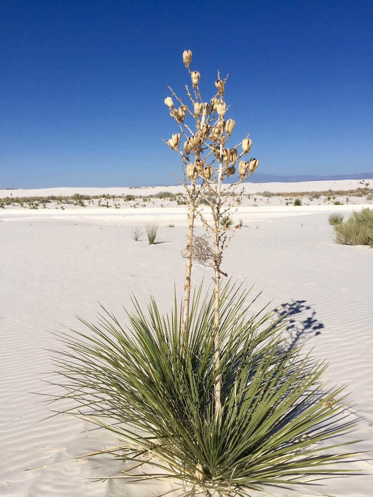 |
Quote: “As sand buries a soaptree yucca, its stem
grows longer to keep new
leaves above the sand.
But after the dune moves on, an exposed yucca
[like the one above (brochure
photo)] will soon fall over and die.”
|
 |
Tracks underneath the yucca.
|
 |
| My
first visit to the White Sands National Monument was in summer 1970 with the late Nancy Becker, my Gallaudet classmate. Nice to be back and have that memory with me! |
SATURDAY, OCTOBER 12
I don’t have a swell view of anything from this, my back-in electric only site at the Boot Hill RV Resort. Up front is a row of storage units, there’s a fence behind me, a travel van at my left, and at my right is some sort of wooden concession trailer. The rest of the park, I noticed on a walk, is lovely – some RV sites are covered and they have cabins available for rent. View or no view, it’s a good day to stay put here…rest, read, write.
SUNDAY, OCTOBER 13
On my way at 10:15 a.m. I got back on Rt. 70 and started driving west. I passed the entrance to the White Sands National Monument but that wasn’t the end of it. There was more white sand to view for a few miles on my side of the road…then it was all cacti and other vegetation.
Shortly after driving through Las Cruces I connected to I-10. Distant hills and mountain ranges were within view all around but the terrain along this route was predominately desert. After three hours of driving I arrived at Lordsburg, NM and got a site at the KOA for tonight and tomorrow.
I’ll be crossing into Arizona on Tuesday. I’m almost home…
Amazing MAP hard to believe three months is up and for you to return home! ill be down there over Thanksgiving weekend. hope to see you if you will be in town. thank you for the entertaining posts and enjoyed reading each journal. Safe travels. xoxo
ReplyDeleteThank you for your comment...glad you enjoyed my "adventures!" Your name is provided as "unknown" so I will look forward to the day I find out who you are, smile!
DeleteHi,
ReplyDeleteYou really are having a wonderful time, I'm so happy for you but I envy you at same time.....lollll......We will talk later. Take care! Hugs and kisses.